![Ways of knowing cities cover [f] mech 276pp front](https://d37vpt3xizf75m.cloudfront.net/api/file/JbY3LEAOR1Ku35PHwYV1/convert?fit=max&h=&quality=95&w=1600&compress=true&fit=max)
Introduction
Introduction
Norms
1
print edition2
print edition3
Infrastructures
4
print edition5
print edition6
print editionSoftwares
7
8
print edition9
print editionBorders
10
print edition11
print edition12
13
print editionMaps
14
print edition15
print edition16
print editionAppendices
Introduction
Cities Full of Data: A Preface
Historically, maps and data have shaped urban lives. With its capacity to represent the spatial world, data has the power to operate on, intervene in, and change the built environment around us. Cities can (and should) be investigated with data, but they are also built, renewed, and scarred by it as well. This is not simply a proposition: it is a call to action.
This book aims to address directly the modes in which cities are represented and thus inhabited. It is a book about techniques and technologies of knowledge, about the tools and practices through which cities are understood. One of those ways of knowing—and not just one among others—is mapping. This book seeks to confront the authority of maps and the data that underlies them, digital and predigital, in order to show how these representations are tools that actively redraw, rebuild, and remake cities. Going far beyond simply representing them, data has fundamentally shaped the look, layout, and lives of cities. John Snow’s 1854 cholera map of London, Jacob Riis’s photographic documentation of tenement life in late nineteenth-century New York City, and the Bombay Improvement Trust’s response to Bombay’s plague of 1896, for instance, have each demonstrated the ways in which the collection and presentation of empirical data can have radical effects on the restructuring (or the “modernization”) of cities. These effects are not always progressive. Robert Moses rebuilt New York City with the help of census records and housing and transportation data, and he created a set of “slum clearance” maps that disproportionately displaced people in neighborhoods of color. In Philadelphia, and many other American cities, the federal Home Owners’ Loan Corporation and the Federal Housing Administration covertly maintained a policy of racial segregation for decades by linking demographic data with mortgage-lending maps.1
Whereas Snow collected his information on foot and drew his map by hand, contemporary cities are prodigious generators of information: quantitative and qualitative, automated and manual. Everything—from tax and real estate information to 911 and 311 call center statistics to GPS devices in taxis and mobile phones to access card and point-of-sale swipes to health records, public opinion surveys, and social media posts and “likes”—can be acquired, analyzed, mapped, and visualized. These visualizations show us patterns, habits, clusters, secrets, flows, and stoppages. They present the city as ripe for improvement, intervention, control, regulation, and automation.
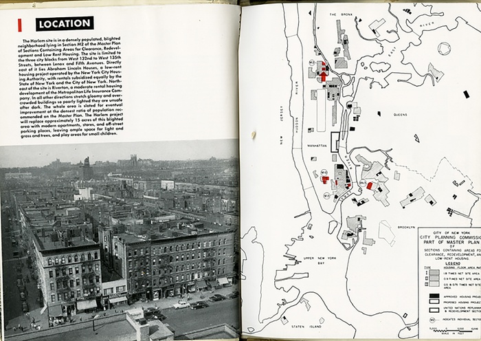
Fig 1: “Harlem: Slum Clearance Plan Under Title I of the Housing Act of 1949” (New York: Committee on Slum Clearance Plans, 1951).
As “smart city” discourses make louder and louder claims for calculable and omniscient urban futures, the problematic histories of the use of data for urban “improvement” seem to fade further out of earshot. Twenty-first-century segregation and exclusion are produced and reinforced algorithmically. Redlining maps have been supplemented with predictive policing, ubiquitous dataveillance, facial recognition, and geolocation systems. The social geography of our cities is being rearranged, often automatically, with digital spatial data. It is true that data can transform our knowledge of cities in remarkable ways, sometimes in the direction of equality and justice, but we must be alert to the dangers that lurk in the smart city and in the data that shapes it.
Many of the essays that follow display a deep ambivalence about data’s effects on cities—what Trevor Paglen has referred to as the “monsters in the smart city.”2 This is an apt metaphor with which to critique the ideology of data-driven cities and the explosion of machine seeing and artificial intelligence in the corporate as well as civic uses of our collectively produced data—our likes, our votes, and our movement—for profit, predictions, and policing. It is an apt metaphor, as well, for the uncertainties and biases these practices have engineered in cities. Paglen’s monsters are the largely invisible mathematical and technological components busily calculating a future city, predicting the behavior of its citizens, and creating environments of fear. They are the instruments that drive the contemporary monitoring, privatizing, and policing of individuals and groups, as well as public space in cities.

Fig 2: Trevor Paglen, Untitled (Reaper Drone), 2013. C-print, 48 × 60 inches (121.9 × 152.4 cm). Courtesy of the artist and Metro Pictures, New York.
Caspar Vopel’s 1558 map of the world represented the space “beyond”—which is to say, the space that cartographers did not know how to measure or represent—as inhabited by monsters, frightening deep-sea creatures.3 Today, there is no lack of knowledge about how to measure and represent even the most complex multidimensional spaces that merge the physical and the virtual in ways unimagined only fifteen years ago. But to most of us, the techniques generating today’s monsters remain enclosed in black boxes, opaque in their mathematical complexity, and hidden behind daunting firewalls and terms-and-conditions pages.
Ever since the news broke in 2015 that Cambridge Analytica betrayed fifty million Facebook users by revealing nine hundred points of data about each one of their profiles—their habits, likes, and dislikes—in order to target political advertisements, we have become painfully aware and suspicious of the algorithms that govern our everyday lives.4 The independent journalists at ProPublica fought back with their own algorithm, the “Political Ad Collector,” which holds “advertisers accountable by revealing pitches that only a targeted slice of Facebook users would otherwise see.”5 Algorithms determine (and potentially limit) what we see on social media, decide whom we are similar to and whom we might (want to) be friends with, and make suggestions about what to do, purchase, and believe. And cities are the front lines for these practices. Urban policing algorithms, which link facial recognition with rich databases, increasingly affect the movements and freedoms of millions of people around the world.
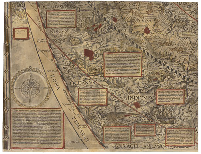
Fig 3: A detail of the Indian Ocean from Caspar Vopel’s map of the world, which includes sea monsters and deep-sea creatures, 1558. Courtesy of the Houghton Library, Harvard University.
These algorithms are another way of knowing cities. There is an urgent need to represent them as such so that we can begin to unpack the black boxes that are quietly transforming urban space and its networks. Few of us are data literate enough to recognize, let alone combat, the algorithms that Virginia Eubanks has so cogently described as “automating inequality” and the ones that Safiya Noble has rightfully described as “algorithms of oppression.”6 Learning how to read data and its effects—and developing strategies and tactics for challenging its authority and its biases—is one of the most essential political tasks of our moment.
One might not have said this a few decades ago. In the mid-1990s the Wired generation declared the “independence of cyberspace,” and an Internet service advertisement for the telecommunications company MCI described a space where there is no race, no gender, no age, no disability—“only minds.”7 A real space but one freed from physicality. “Not utopia but the Internet.”8 A decade and a half later, William Gibson, who coined the word “cyberspace,” noted that in the age of Google, “cyberspace has everted. Turned itself inside out. Colonized the physical.”9 And by the time of Brexit and the 2016 US elections, data came to stand for fake news, filter bubbles, psychographic profiling, and scissor statements.10 It seemed a rather abrupt reversal away from data optimism and toward data pessimism.
For many of those studying cities, though, this opposition was not clear-cut, and the narrative of reversal—the taming of hope by experience—seemed much too simple. Cities have never been just collections of people and buildings but rather dynamic networks of relationships that generate data, operate with data, and are transformed by data—for better and for worse. Optimism and pessimism are equally irrelevant categories here. In order to understand cities, then and now, data is unavoidable: it needs to be understood, harnessed, confronted, and critically examined. Cartographers, GIS users, and urban scholars have long researched the confusing ways in which data has shaped urban space and the ways in which those urban epistemologies have resulted in more and less spatial equality.
Understanding how data and maps shape space is urgent work, and work that cannot be done at a distance—either from data or from cities. “Spatial research” names a mode of working with spatial data to discover what can be done and undone, learned and unlearned with it.
Data is always a matter of translation. Things and people and events are observed, measured, and abstracted into numbers and pictures—static and dynamic. Not all, but much of that data has a spatial component: what was measured happened somewhere, and that location is itself part of the data. When data is spatial and depicted on maps, the practice might as well be called data visualization.11 Today the preeminent icon for this type of data visualization is the geographic information system (GIS) framework itself—a way of knowing that combines a database of information about things happening in space with a cartographic or geographic description of the physical world. Geolocation is all. Any point that has a unique address can be mapped.
Maps as images are familiar features of the media landscape. They appear each day in our newspapers and on our screens to tell us how we voted, how storms have flooded and will flood cities, what’s happening on the southern border of the United States or in the Mediterranean. Maps are the background against which all sorts of data have been collated to create an interpretation of a spatial condition. Urban versus rural voting patterns can be juxtaposed each election cycle; nation-states can be compared for population growth and gross domestic product; cities can be monitored for sprawl over time; neighborhoods can be differentiated according to crime statistics and high school graduation rates; social networks can be evaluated for how similar your friends are to you.
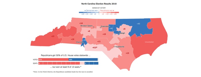
Fig 4: Maggie Astor and K. K. Rebecca Lai, “What’s Stronger Than a Blue Wave? Gerrymandered Districts,” New York Times, November 29, 2018. Courtesy of the New York Times. © 2018. The New York Times Company. All rights reserved.
These maps show a lot.
First, they show us their own limits. Maps are, in fact, arguments about constraint. They cannot help but foreground one boundary over another: police district or school district, country or state, census tract or voting district, city block or building. Circumscribing data is never a neutral act. In terms of resolution, maps display the limits of the image-making technology they rely upon: what they can show (for example, the measurement of a pixel on a satellite image) depends on just how finely grained their sensors and representations are. Some maps let us play with these constraints—for instance, by changing the scale (or the zoom) that determines what is and is not visible at any given moment—and thus underline the irreducible nature of limitation itself.
To speak of constraint is to speak of power, and that is the second essential metadisplay made by maps. Maps, and the technologies and imaginations used to produce them, are instruments of power.12 Not of Power but of the exercise of power in conflicts, relationships, encounters, challenges, battles, protests, and subversions. Maps are never just navigational aids or aesthetic objects; they live essentially in the force field of social, economic, and political struggle.
Unlike charts and graphs, GIS maps are spatial representations—spatial icons of statistics. The seamlessness of this type of cartographic image often allows us to overlook the fact that the map is a presentation of spatial statistics—an argument about something in the world analyzed from a dataset and projected onto a map. Therefore, we need to address data as its own entity, as a medium that informs the map. Data’s limits affect not only the generation of maps but also their use. Data cannot be interpreted or read without knowing the constraints (or conditions) that govern its collection and representation. It is a part of the social, political, economic, racial, and gendered world it represents. There is no such thing as raw data. Long lists of numbers or lines of text may appear “raw,” but that is merely a presentational device. Numbers and text become data only when people observe them, read them, make claims about them—and the meaning or output of this information depends on the political and social resources available to observe it. Data is always collected for a purpose and constrained by the people, institutions, or machines that collect it. Nothing about data, despite the etymology of the word, is given: not the numbers, the rules for analyzing them, or the forms in which we see them. Without observation, decision, translation, interpretation, and memory—which is to say, without intervention—there would be no data. Data is taken, not given.
This fact implies three provisional conclusions. First, if spatial research is about the political, aesthetic, and operational epistemologies of cities, then data and maps must display not just their “content” but also their limits. Second, because political and ethical choices are embedded in urban data, it’s essential to open up the black boxes (technical and otherwise) that generate and process it, and to exercise some agency over its meanings and uses. Third, we should acknowledge that data-driven “smart” cities have long histories (no matter how analog that “smartness” is), which often underlie the spatial conflicts that have become so visible today.
The chapters that follow propose a political orientation toward data and maps as resources for knowing cities differently. Some of them emphasize technical mastery, others data literacy, still others countercartographies. They all, in different terms, ask us to interrogate the inherited frameworks through which we think we know cities. They contest and confront the ways in which “knowledge” and “technology” are thought to be synonymous with progress in cities. Progress, after all, is just one mode of narrating historical change. Here, readers will find a multiplicity of other, more nuanced ways in which knowledge and technology can be thought together to understand the rich historicity of cities—and to rethink their futures.
LAURA KURGAN is professor of architecture at the Graduate School of Architecture, Planning, and Preservation at Columbia University, where she directs the Center for Spatial Research and the Visual Studies curriculum. She is the author of Close Up at a Distance: Mapping, Technology, and Politics (Zone Books, 2013). Her work explores the ethics and politics of digital mapping and its technologies; the art, science, and visualization of big and small data; and the design of environments for public engagement with maps and data. In 2009 Kurgan was awarded a United States Artists Rockefeller Fellowship.
For specific data on the topic, see Digital Scholarship Lab, “Renewing Inequality: Urban Renewal, Family Displacements, and Race 1955–1966,” American Panorama, ed. Robert K. Nelson and Edward L. Ayers, http://dsl.richmond.edu/panorama/renewal/#view=0/0/1&viz=cartogram&city=newyorkNY&loc=11/40.7140/-73.8890.
These monsters live and work in the environment of “surveillance capitalism,” a term explored by Shoshana Zuboff in her book The Age of Surveillance Capitalism: The Fight for a Human Future at the New Frontier of Power (New York: PublicAffairs, 2019). Trevor Paglen was a keynote speaker at the “Ways of Knowing Cities” conference at Columbia University, February 9, 2018, https://www.arch.columbia.edu/events/816-ways-of-knowing-cities; he presented recent artwork in five chapters titled Monsters in the Smart City, which can be viewed here: http://c4sr.columbia.edu/knowing-cities/schedule.html#tpaglen?r=sch.
Greg Miller, “Why Ancient Mapmakers Were Terrified of Blank Spaces: Inventing Cities, Mountains, and Monsters to Fill the Empty Spaces on Maps Is a Centuries-Old Tradition in Cartography,” National Geographic, November 20, 2017, https://news.nationalgeographic.com/2017/11/maps-history-horror-vacui-art-cartography-blank-spaces.
Kevin Granville, “Facebook and Cambridge Analytica: What You Need to Know as Fallout Widens,” New York Times, March 19, 2018, https://www.nytimes.com/2018/03/19/technology/facebook-cambridge-analytica-explained.html.
Jennifer Valentino-DeVries, “Outlets in Eight Countries Are Using Our Tool to Monitor Political Ads on Facebook,” ProPublica, February 8, 2017, https://www.propublica.org/article/outlets-in-eight-countries-are-using-our-tool-to-monitor-political-ads-on-facebook.
See Virginia Eubanks, Automating Inequality: How High-Tech Tools Profile, Police, and Punish the Poor (New York: St. Martin’s Press, 2018); and Safiya Noble, Algorithms of Oppression: How Search Engines Reinforce Racism (New York: New York University Press, 2018).
John Perry Barlow, “A Declaration of the Independence of Cyberspace,” Electronic Frontier Foundation, February 8, 1996, https://www.eff.org/cyberspace-independence. This ideology was echoed in a television commercial by MCI in 1997; you can view “The Anthem” on YouTube, https://www.youtube.com/watch?v=ioVMoeCbrig.
MCI, “The Anthem,” https://www.youtube.com/watch?v=ioVMoeCbrig.
William Gibson, “Google’s Earth,” New York Times, September 1, 2010, https://www.nytimes.com/2010/09/01/opinion/01gibson.html.
Scott Alexander, “Sort by Controversial,” Slate Star Codex, October 30, 2018, https://slatestarcodex.com/2018/10/30/sort-by-controversial.
Laura Kurgan, Close Up at a Distance: Mapping, Technology, Politics (New York: Zone Books, 2013).
J. B. Harley, “Deconstructing the Map,” Cartographica 26, no. 2 (Summer 1989): 1–20.
Introduction
Ways of Knowing Cities: An Introduction
Technology is changing how we know and experience cities: sensors, satellites, machine vision, and predictive algorithms are transforming both the daily rhythms of city life and the political economic ordering of the urban world. Cities have always been instantiated through historically specific technologies, but the scale, pace, and pervasiveness of these changes are unprecedented. Ways of Knowing Cities addresses this accelerated condition, considering the role that technologies have played in altering how urban space and social life are structured and understood in varied locations, across different historical moments. From a broad range of disciplinary perspectives, the essays in this book investigate the relationship between “technology” and “the city” as distinct entities, and also provoke a reevaluation of these terms as analytic categories.
This reevaluation comes at a time when the very concept of the city is in flux.1 Much of the project of urban theory has been to generalize an abstracted concept of the city by studying the spatial arrangements and social patterns of particular urban places—all too often in Europe and North America. Scholars have increasingly begun to call this parochialism into question, challenging the sites and biases upon which canonical urban theory has been based. In a call for new geographies of theory, Ananya Roy urges a closer consideration of how theory and site interact, of how cities inform “the city.” She decries the “limited sites at which theoretical production is currently theorized and… the failure of imagination and epistemology that is thus engendered.”2 Roy argues for new geographies to ground theory—new forms of urban knowledge reliant upon a broader and different set of places, embodiments, and experiences. In a related critique—as a means to address the global profusion of urban forms that are arguably no longer meaningfully described by the city concept—David Wachsmuth posits that the city ought to be treated as a “category of practice, as a representation of people’s relationship to urbanization processes, rather than as a category of analysis adequate to describe these processes themselves.”3 Following this, Wachsmuth diagnoses a dynamic that, together with Hillary Angelo, he describes as “methodological cityism”: forms of contemporary urban analysis that are ill-equipped to describe the conditions they aim to decipher. In their view, these projects fail to fully comprehend the varied impacts of urbanization processes because they assume a particular set of scalar, social, economic, and power relationships endemic to the concept of the city that no longer hold—and take for granted certain relationships between labor and sites of production, between settlement patterns and local economic structures, between the spatial imaginaries of urban dwellers and the bounded agglomeration that is “the city.”4
The essays contained here speak to these uncertainties within the fields of urban studies. They trace histories of urban epistemologies; untangle methodologies of theory; address sites, technologies, and discourses where the question of knowing cities is being actively worked out; and propose alternative practices for measuring and drawing urban life. Through them, a new set of concrete sites and forms of engagement comes into view, addressing topics including the proliferating apparatuses of border policing in the Mediterranean; the battles over stolen electricity in Manila; the calcification of forgotten histories of segregation within axioms of network science; the emergence of new publics through strawberry plants that monitor air quality in Amsterdam; and the evasion of police surveillance by Black queer love. Taken together, the essays in this book reveal that the ways the city, and its inhabitants, have been comprehended in moments of technological change have always been deeply political. Representations of the urban have been sites of contestation and violence, but they have also enabled spaces of resistance and delight.
Ways of Knowing Cities stages a conversation across disciplinary ways of knowing in order to interrogate how certain epistemologies are predicated on the erasure of others. To frame this conversation and future ones, the book is organized according to “Assumptions,” “Infrastructures,” “Softwares,” “Borders,” and “Maps.” There are, of course, areas of overlap between these terms, as well as other meaningful commonalities across pieces not captured by these particular categories. As lenses, or as points of entry, the categories offer a guide for how the book operates together and across its individual elements—and for how the approaches in this volume play off one another. Yet, just as these organizing frames offer distinct ways of reading narratives, histories, technologies, sites, and urban realities, they also reveal, in the spaces between them, new urgencies and unaddressed questions.
“Assumptions” deals with how the city becomes legible and presents alternative modes of reading urban space and urban life. These essays provide examples of the ways in which the processes and frameworks that make sense of the city are shaped by (and in turn perpetuate) longstanding ideological positions or biases—of how colonial, racist, or neoliberal forces are masked by their presentation as “normal,” commonsense, abstract, and statistically significant. The essays gathered within this frame destabilize accepted terms and question what is ordinarily considered “given” as they address the ideological and disciplinary underpinnings of how we come to know and decipher the city. In this way, they offer new histories, contextualize underlying assumptions, and propose new forms of engaging with the politics of legibility.
Orit Halpern takes up resilience, a key paradigm for contemporary urban practices, to unpack its underlying assumptions. She reminds us of the scientific origins of the term and focuses attention on how the concept has been appropriated as a logic for urban governance and intervention that naturalizes certain kinds of precarity—an epistemology of urban management that prioritizes technological fixes to the system “at the cost of the survival of any of its particular components.”5 Wendy Hui Kyong Chun traces the reflexive and historical relationship between network science and the city. Her piece unravels several studies to show how network science, which is increasingly used to describe and model the city—and which stands in for and acts as a form of urban theory (depending on whom you ask)—is rooted in a model of segregation in US cities. “Homophily”—the tendency for similar things or people to group together—is “a starting place [that] cooks the ending point it discovers… [it] imposes, naturalizes, and projects the segregation it finds,” she writes.6 Built upon midcentury urban sociology, network science eclipses its historical foundations, ignoring the ways in which urban systems are socially constructed and instead taking their forms as natural. Risk and technological innovation work together here as the inputs of and alibis for financial speculation. Simone Browne uses the film Naz & Maalik as an entry point to consider Sylvia Wynter’s notion of “deciphering practice” as a model for crafting anticolonial futures. Browne travels to other contemporary examples of state violence perpetrated against everyday Black life, revealing how such violence is justified through statistical modes of representation and normalized through lasting forms of colonial oppression. The relationship between the film’s protagonists (and the way it is interpreted by the police and FBI officers tracking and surveilling them) provides an entry point for Browne to name the ways in which Black queer love in urban spaces has radical potential to recast normalized forms of violence for what they are. The piece makes explicitly clear the political and everyday significance of deciphering—of making sense of—cities.
“Infrastructures” considers the materiality of the city, bringing together essays that examine the ways in which infrastructural systems inscribe meaning in urban environments and the ways such systems aim to both rationalize and transform the city. These essays testify to the impact of infrastructural solutions, to the ways power is materialized and contested through these systems, and to the ways cities, as purveyors of resources, are built and transformed through conflict. They name these effects as historical phenomena that also persist today despite increased deployment of smart city solutions that appear to flatten difference and inequity. Together, the essays speak to the ways that rights to the city are negotiated through infrastructure—the technopolitics of infrastructure.7 At stake in each of these accounts is the ability to influence or control the conditions (and conditions of possibility) of the material city and the imaginaries, hopes, and other forms of human flourishing that this material city can enable or foreclose.
Mitch McEwen situates the crisis of water shutoffs in urban Detroit as the end point of more than half a century of design, policy, and rate-structure decisions shaping the spatial order of the city. Drawing on the work of Keller Easterling, McEwen positions these developments as a form of “extrastatecraft”—existing beyond ordinary political processes yet directly impacting the daily life, financial stability, health, and well-being of Detroit’s residents. It is a story of water that reveals the way in which resource management has made, and continues to make, an unequal city. Dietmar Offenhuber interprets a program to overhaul Manila’s consumer electricity grid as an example of how infrastructures usher in, and are sites of contestation over, new forms of governance in the era of the “smart city.” Informality and platform urbanism are brought into direct contact and confrontation as the private utility’s new program borrows the logic of improvisation from the ad hoc, fragile, contingent, and varied local electricity connections to control practices of unmetered, pilfered electrical usage. In this fraught terrain, complex responses to the smart city paradigm are possible and written into lampposts and electrical lines. Laura Kurgan, Grga Basic, and Eva Schreiner describe research and mapping work that examines the deliberate urban and infrastructural damage inflicted in Aleppo during the Syrian civil war. The power of the state to designate certain forms of infrastructure as “informal” emerges, seemingly, as a tactic of the Assad regime to control who is allowed to shape the (future) city of Aleppo.
“Softwares” tackles the “smart city,” the overused moniker used to describe a wide set of practices that combine information communications technologies and contemporary urbanism. It implies, in various contexts, software, hardware, ideology, political organization, analytical regimes, or all of the above. At times “smart” urbanism is marketed as an alternative to politics. Often it is modeled on Euro-American conceptions of technology, specifically centered in a Silicon Valley ethos. Proponents of the smart city often claim that it eliminates the need for other interpretive regimes—“smart” implies an already full knowledge of the city and thus minimizes the need for other forms of knowing. The essays in this section respond to this monopoly of knowledge by proposing and recovering alternative epistemologies, (re)claiming the right to the city.
Shannon Mattern traces several histories of urban media, providing vignettes that illustrate how the city has long been transformed by communications infrastructures. Roman and Islamic epigraphy, telegraph lines that coated cities like Stockholm in dense fibrous webs, and the role of the telephone in the making of the modern skyscraper all “embody urban epistemologies and… ‘program’ the material city.”8 Mattern argues that the logic of “disruption,” so often touted by contemporary smart city projects, is made possible by ignoring or rewriting these histories. Anita Say Chan speaks to the limits of liberalism at the heart of smart city discourse and challenges the affective politics of car—urban, social, economic––that underwrite Silicon Valley-driven urbanism. Through an ethnography of a Lima-based coding school, Chan names the ways that start-up logics are imposed along with their assumptions about the lives of tech knowledge-sector workers—even as these are deeply out of touch with their urban context—and the ways that, in their pursuit of innovation, “smart” projects often attempt to disrupt a set of imagined conditions that do not actually exist. B. Coleman summons the “escape artist” as a figure of civic engagement that provides a model for claiming rights to the city in the context of “smart” neoliberal urban governance. Whether amplifying local knowledge through a system of data collection rather than mimicking authoritative ways of measuring in Amsterdam; organizing efforts against gentrification that reinterpret official data sources in Jakarta; or physically transforming iconic symbols of modernity into layered sites with complex meanings in Mumbai, for Coleman, these discrete instances manifest the right to representation, the right to resist, and the right to disappear.
“Borders” engages in forms of practice that alter, bend, and map conditions of exclusion and violence, belonging and displacement. Each essay troubles the relationship between media, bordering practices, and urban space. They point to the complex relationships between movement, nation, and city to ask: what does citizenship mean amidst diaspora and how is it encoded in urban space? How have responses to perceived crises of migration, made in the name of defending national boundaries, altered relationships between nation, city, and territory? And what is the role of representation in these contexts?
Tinashe Mushakavanhu and Nontsikelelo Mutiti, a graphic designer and journalist pair, discuss an ongoing project to construct an archive of Zimbabwean literature: Reading Zimbabwe. Moving between the archive as a whole and the work of author Dambudzo Marechera within it, the essay traces how literature demarcates and is demarcated by expectations of emplacement and othering—how it creates and sustains often vexed ideas of home and belonging. Reading Zimbabwe aims to map national identity and diaspora through taking up “issues of memory, the afterlives of colonialism, and the forms of narrative that are commensurate to telling a nation’s stories.”9 In a second piece, Mutiti describes a series of recent design projects that engage African diasporic urban experiences, mapping a countercity through hair braiding salons and other spaces and practices of Black hair aesthetics. Maribel Casas-Cortés and Sebastian Cobarrubias address the constellation of mechanisms that have been used to alter the ways that migration is policed in the European Union. New technologies have allowed for practices of border externalization by which migrants are tracked and stopped far before the geographic borders of the countries they are attempting to reach. This creates new kinds of interstitial spaces, new conceptions of nation and city. Lorenzo Pezzani and Charles Heller recount migration in the Mediterranean. They argue that the policing of migrants in this landscape is a form of media practice where the sea itself is “mobilized in the context of border control to constitute a perilous liquid mass.”10 Their work reveals the ways in which these media practices, ways of knowing, have created “hostile environments.” Their project, Forensic Oceanography, uses the same techniques of detection and image- making that are used to render migration illegal but shifts the object of focus to the violence of the border itself.
The final lens explicitly examines “Maps” as a key technology of urban research—of knowing the city—and offers possibilities for alternative cartographies. The essays here provide examples of critical practices that bring multiple disciplinary apparatuses to bear on making and interpreting representations of the city in maps and archival material. Each piece addresses fundamental tensions inherent in flattened representations of the city and its social processes—the tensions between lived experience and geographic measures, between fixing time and examining space, between authoritative explication and interpreted narrative. They each offer suggestions for how the “worlding” ability of maps might be enacted, as well as new, more pluralistic approaches to reading and making the city through its representation.
Eve Blau describes a collaborative project from the Harvard Mellon Urban Initiative, which experiments with techniques for studying, accumulating, and reading urban archival materials. Through investigations in Berlin, Boston, Istanbul, and Mumbai, Urban Intermedia: City, Archive, Narrative explicitly attempts to develop a method for urban research across and between disciplinary perspectives “through a shared media language,” enacted through the literal assembly of archival materials in animated narrative collages.11 Matthew W. Wilson provides a history of animated maps in order to communicate how they push the boundaries of cartographic interpretation. Drawing on cinema theory to reinterpret these representational forms, he argues that “‘maps that move’ might mobilize design to think about the intervention in cartography differently, as shifting the ways the world is experienced and represented, to be for space in all its liveliness, surprise, and disruption.”12 In the context of the recent surge of interest in, and accessibility of, geographic information systems softwares, Leah Meisterlin revisits the key building blocks of all geographic analysis: measures of location, area, and distance. In particular, she describes recent work on reformulating understandings of distance and charts, with remarkable clarity, the way that the “analytical assumptions and geographic preconceptions” built into tools of geographic analysis have created and “reinforced a totalizing map logic that (literally, figuratively, and representationally) bounds the types of knowledge produced via cartographic reasoning.”13 The impact of this work is profound, as it suggests nothing less than a reformulation of the very ground on which cartography sits.
Addressing themselves to the contentious and varied relationships between technology and the urban, the essays gathered in this book offer diverse geographies, prose, objects of analysis, and modes of interpretation. Each piece operates at a different register, whether transforming current theoretical approaches, reading cultural forms, or offering concrete tactics. Across and between these varied approaches, they problematize the city “container,” in some cases explicitly constructing analytic geographies based on experience, in others defining place relationally and sketching out meaningful codependences that cross sites and scales. In response to present uncertainties within the fields of urban studies and to the far too limited locations through which the city is currently theorized, these essays extend many points of entry, signposts, and models for thinking and making cities anew. Premised on the urban as a process rather than as a discrete site, the essays that follow catalyze more robust, more creative, and more far-reaching ways to think about the relationship between the city and the information systems that enable, engage, and express it at a critical juncture in our collective urban life.
DARE BRAWLEY is a researcher and designer. She is assistant director of the Center for Spatial Research at the Graduate School of Architecture, Planning, and Preservation at Columbia University. Her work focuses on the interactions of technology, urban governance, and spatial politics using methods from critical urban studies and geographic information systems. Her work has been exhibited at and published by the Venice Architecture Biennial, Storefront for Art and Architecture, the Architectural League, the Lincoln Institute of Land Policy, and the Chicago Architecture Biennial.
See, for example, the work of the Urban Theory Lab. Neil Brenner, “Theses on Urbanization,” Public Culture 25, no. 1 (January 2013): 85–114, https://doi.org/10.1215/08992363-1890477; Neil Brenner, Implosions/Explosions: Towards a Study of Planetary Urbanization (Berlin: JOVIS, 2014), http://public.eblib.com/choice/publicfullrecord.aspx?p=4566677; Neil Brenner and Christian Schmid, “Towards a New Epistemology of the Urban?,” City 19, no. 2–3 (May 4, 2015): 151–182, https://doi.org/10.1080/13604813.2015.1014712; Neil Brenner, “Debating Planetary Urbanization: For an Engaged Pluralism,” Environment and Planning D: Society and Space 36, no. 3 (June 1, 2018): 570–590, https://doi.org/10.1177/0263775818757510.
Ananya Roy, “The 21st- Century Metropolis: New Geographies of Theory,” Regional Studies 43, no. 6 (July 2009): 819–830, https://doi.org/10.1080/00343400701809665.
David Wachsmuth, “City as Ideology: Reconciling the Explosion of the City Form with the Tenacity of the City Concept,” Environment and Planning D: Society and Space 32, no. 1 (February 1, 2014): 87, https://doi.org/10.1068/d21911.
Hillary Angelo and David Wachsmuth, “Urbanizing Urban Political Ecology: A Critique of Methodological Cityism,” International Journal of Urban and Regional Research 39, no. 1 (January 2015): 16–27, https://doi.org/10.1111/%28ISSN%291468-2427/ issues.
See Orit Halpern, “Hopeful Resilience,” in this volume.
See Wendy Hui Kyong Chun, “Ways of Knowing
CitiesNetworks,” in this volume.Brian Larkin, “The Politics and Poetics of Infrastructure,” Annual Review of Anthropology 42, no. 1 (October 21, 2013): 327–343, https://doi.org/10.1146/annurev-anthro-092412-155522.
See Shannon Mattern, “Ether and Ore: An Archaeology of Urban Intelligences,” in this volume.
See Tinashe Mushakavanhu and Nontsikelelo Mutiti, “Minding the Gaps: Navigating Absences in the Zimbabwean Imaginaries,” in this volume.
See Lorenzo Pezzani and Charles Heller, “‘Hostile Environment’(s): Sensing Migration across Weaponized Terrains,” in this volume.
See Eve Blau, “Urban Intermedia: City, Archive, Narrative,” in this volume.
See Matthew W. Wilson, “Maps that Move,” in this volume.
See Leah Meisterlin, “Cartographies of Distance,” in this volume.
Norms
1
Hopeful Resilience
2
Ways of Knowing Cities Networks
3
For Maalik, Naz, Brittany & Alexis: Or, Deliberate Acts of Disruption in City Space
“If you’re here with the NYPD or you’re with the FBI, welcome, sincerely. We expect you here.” This is the brief greeting spoken by an imam at the beginning of a prayer gathering depicted in the 2015 film Naz & Maalik (directed by Jay Dockendorf).1 This welcoming to the mosque is a recognition of and, perhaps, a reckoning with the seeming inevitability of police surveillance and monitoring of Muslim communities, by, for example, the (now disbanded) Demographic Unit of the New York Police Department (NYPD). Of course, the surveillance of Muslims in the United States is not a recent phenomenon; mosques and Muslim student groups were being infiltrated by plainclothes cops or through the work of FBI informants and by way of “create and capture” long before the current president (then candidate) proclaimed: “I want surveillance of certain mosques, okay… and you know what? We’ve had it before and we’ll have it again.”2 One need only look to the thousands of pages of declassified FBI files on Muhammad Ali, Malcolm X, Elijah Muhammad, and the Nation of Islam that reveal, through redaction and nondisclosure, the extent of the state’s targeted actions.
Naz & Maalik follows the title characters, two Black, queer, Muslim teenagers, as they move in and around Brooklyn by foot, bike, and train in the course of one day. Their conversations range widely, skimming topics from the gentrification of Brooklyn to the Qur’an, bystander intervention, prisons, and profiling at airports. At one point, they are approached by a white, greasy-haired undercover NYPD cop who attempts to entrap the two into buying a gun. Unsuccessful, the cop reports the teenagers to an FBI agent sitting in a black sedan. These scenes depict “create and capture”: the making of informants whereby the FBI (allegedly) outfits its targets with terrorist starter kits in order to manufacture and then seemingly foil terrorist plots.3 Maalik and Naz sell various things (Catholic saint cards, lottery tickets, perfumed oils) along Fulton Street to raise some cash, but it is their loving on each other in public that makes them illegible to the FBI. Their acts of loving on each other while moving through the city—while riding the L train, for instance—are cautious because of the homo-antagonistic surveillance of family, school, and the public. This illegibility renders them all the more suspicious to the FBI agent in the black sedan.
I want to hold on to the Maaliks and the Nazes, but not Naz & Maalik, for how they allow me to think with what Sylvia Wynter calls the “practice of decipherment” in her essay “Rethinking ‘Aesthetics’: Notes towards a Deciphering Practice.” In it, she writes about a mode of critique that “seeks to identify not what texts and their signifying practice can be interpreted to mean but what they can be deciphered to do,” and how.4 It is a way of getting at, as Rinaldo Walcott puts it in his discussion of that same essay, “a reconstituted universalism proffered from the vantage point of the subaltern and the dispossessed.”5 Therefore it moves toward altering our current epistemological order rather than merely being a form of criticism that is enfolded into, as Wynter puts it, “the instituting of the ‘figure of man’ and its related middle-class subject (and the latter’s self-representation as a genetically determined rather than discursively instituted mode of being).”6 Black queer love in public makes possible an anticolonial reading of the Maaliks and the Nazes in the time of (for example) stop and frisk, the police torture that is Chicago’s Homan Square, the FBI’s proposed Shared Responsibility Committees, its “Don’t Be a Puppet” website, and the Department of Homeland Security’s monitoring of Black Lives Matter movements.
With this frame, I turn to, first, the leaked Unclassified/For Official Use Only FBI intelligence assessment “Black Identity Extremists Likely Motivated to Target Law Enforcement Officers” (2016) and then briefly to the recent documentary Whose Streets? (directed by Sabaah Folayan, 2017), which offers guideposts for anticolonial action. In this way, what follows is not an essay strictly on US surveillance policies with regard to the war on terror, or on state and state-sanctioned violence against everyday Black life. Instead, by foregrounding Naz & Maalik (again, for the sake of the Maaliks and the Nazes rather than the film itself) and asking what this text “can be deciphered to do,” I am suggesting that Black queer love of Black people is a liberatory practice and strategy for confronting the gendered violences of anti-Black police terror. This claim is obvious and not revelatory; see, for example, Black Lives Matter—Toronto’s list of demands and their queer-positive Freedom School for children, or the Movement for Black Lives’ platform statement: “We are intentional about amplifying the particular experience of state and gendered violence that Black queer, trans, gender nonconforming, women and intersex people face.”7 But calling attention to Black queer love of Black people as a liberatory practice suggests that it is a deliberate enactment of anticolonial politics against a colonial system and all of its makings: white supremacy, capitalist exploitation, the white settler state’s logic of indigenous dispossession and bureaucratic disavowal, anti-Black terrorism, and heteropatriarchal violence. I use the term “anticolonial” intentionally, as decolonial transformations can be fleeting. They morph and mutate. They can be reincorporated, or structurally adjusted, so to speak, into new systems of violence. “Anticolonial” calls attention to the continuous groundwork and deliberate acts of disruption that are necessary to hold the world that we want to get to someday—a world that is something other than this colonial one—to its promise of liberation.
Prepared by the FBI’s Domestic Terrorism Analysis Unit, the August 2016 intelligence assessment marks the creation of a new classification: the Black Identity Extremist (BIE). The FBI defines this identity, in a rather incomplete, confounding, and probably deliberate fashion, as “individuals who seek, wholly or in part, through unlawful acts of force or violence, in response to perceived racism and injustice in American society and some [sic] do so in furtherance of establishing a separate black homeland or autonomous black social institutions, communities, or governing organizations within the United States.”8 The document cites the killing of Michael Brown in Ferguson, Missouri, in August 2014 and the grand jury’s decision not to indict the cop who killed him as the “very likely” impetus for the rise of this new classification—one that is now part of the FBI’s catalogue on the surveillance of Black life and the criminalization of Black political struggle. According to the leaked document:
The FBI assesses it is very likely that BIEs’ perceptions of unjust treatment of African Americans and the perceived unchallenged illegitimate actions of law enforcement will inspire premeditated attacks against law enforcement over the next year. This may also lead to an increase in BIE group memberships, collaboration among BIE groups, or the appearance of additional violent lone offenders motivated by BIE rhetoric. The FBI further assesses it is very likely additional controversial police shootings of African Americans and the associated legal proceedings will continue to serve as drivers for violence against law enforcement.9
I quote from the leaked document at length here because it is an instrument of the FBI’s power to index certain Black political struggles as internal threats to US national security. This indexing functions as the state’s alibi and its justification for the repression of any critique or response from Black people when it comes to state violence against Black people and their communities. This leaked twelve-page threat assessment is documentary evidence of the sources and methods of the state’s anti-Black surveillance rationales. The document states that “The FBI only uses likelihood expressions” and “does not derive judgments via statistical analysis”; instead it claims to present “analytic judgments.”10 However, these analytic judgments (“The FBI assesses” and “it is very likely” when it comes to “perceptions of unjust treatment”) work to produce that very statistical analysis, where “very likely” is equated with “highly probable” and a rate of “80–95%.”11 It is a spurious correlation indeed. However, if we are to take such certainty at face value, then we must read the use of future tense in “will continue to serve” as an unintentional admission that police shootings of Black people will continue along with decisions not to indict, acquittals, or, as in the case of the now former cop who killed Terence Crutcher in Tulsa, Oklahoma, in 2016, all charges being removed from record.12 The rhetoric of statistics as objective, empirical truth—when they are in fact not—is part and parcel of the FBI’s intelligence sources and methods that work to name Black political struggle as an ideological and statistically verifiable threat to police power. The threat assessment does not include any credible specifics about future violent acts targeted at police; instead it only offers the BIE as a category manufactured to trigger, one could guess, the bureau’s counterintelligence tools, which include the recruiting of informants and other methods of discrediting and disruption.
In Whose Streets?, Brittany Ferrell, cofounder of the St. Louis-based organization Millennial Activists United, calls for a different future tense, one that centers a Black queer critique of our current governing order. The documentary follows Ferrell and her partner, Alexis Templeton, throughout their activist work, or caretaking, during the Ferguson uprising and beyond: recording a highway shutdown, their wedding, movement work, community meetings with elected officials, Ferguson October, protests, disruptive acts, and loving acts. Millennial Activists United is a grassroots organization created by Black queer women.13 Their ways of caring demonstrate what Black queer revolutionary love makes possible and what it looks like to love Black people in public space, like their shutdown of Interstate 70 (where a motorist violently drove through the protestors’ human barricade). Their love is strategic, and it is dutiful—they echo Assata Shakur’s words throughout the documentary: “It is our duty to fight for our freedom. It is our duty to win. We must love each other and support each other. We have nothing to lose but our chains”—and it can be summed up in three words: Black Lives Matter.14
At one point in the documentary, Ferrell outlines a method for a deciphering practice: “I just challenge these ideas of normality… if your normal is limited opportunities for people of color, why aren’t you questioning that normal? If that normal is an eighteen-year-old teenager laying in the street for four hours, but that’s your normal, right? Everybody wants things to be normal. I feel like if you are not questioning ‘normal,’ you are not paying attention.” If you are not questioning colonial forms of domination, then you are willfully not paying attention. Although Wynter’s deciphering practice is focused on the texts, like film, that shape the imaginaries of our current governing order, we can still look to it as a means of reading our present to make anticolonial futures. Or, as Ferrell aptly puts it, “it’s that feeling that keeps me going.” If not, we remain, as Wynter warns, “accomplices in an ‘epistemic contract,’” which functions not in the name of liberation but to replicate our current governing order.15
SIMONE BROWNE is associate professor in the Department of African and African Diaspora Studies at the University of Texas at Austin. Her book Dark Matters: On the Surveillance of Blackness (Duke University Press, 2015) was awarded the 2016 Lora Romero First Book Publication Prize by the American Studies Association, the 2016 Surveillance Studies Book Prize by the Surveillance Studies Network, and the 2015 Donald McGannon Award for Social and Ethical Relevance in Communications Technology Research. She is also a member of Deep Lab, a feminist collaborative composed of artists, engineers, hackers, writers, and theorists.
A version of this essay was originally published in Cinema Journal 57, no. 4 (Summer 2018): 138–142.
“Trump: I Want Surveillance of Certain Mosques,” Associated Press, November 21, 2015, https://www.youtube.com/watch?v=RQUwtYWLR3E.
For examples of this build-a-terrorist practice, see Glenn Greenwald, “Why Does the FBI Have to Manufacture Its Own Plots If Terrorism and Isis Are Such Grave Threats?,” The Intercept, February 26, 2015, https://theintercept.com/2015/02/26/fbi-manufacture-plots-terrorism-isis-grave-threats.
Sylvia Wynter, “Rethinking ‘Aesthetics’: Notes towards a Deciphering Practice,” in Ex-Iles: Essays on Caribbean Cinema, ed. Mbye B. Cham (Trenton, NJ: Africa World Press, 1992), 266.
Rinaldo Walcott, “Reconstructing Manhood; or, The Drag of Black Masculinity,” Small Axe 13, no. 1 (2009): 83.
Wynter, “Rethinking ‘Aesthetics,’” 265.
The Movement for Black Lives, “Platform,” https://policy.m4bl.org/platform. For more information on Black Lives Matter–Toronto’s Freedom School, visit their website: http://freedomschool.ca. See also Cathy J. Cohen, “Punks, Bulldaggers, and Welfare Queens: The Radical Potential of Queer Politics?,” GLQ 3, no. 4 (1997): 437–465.
The leaked document continues by noting that “This desire for physical or psychological separation is typically based on either a religious or political belief system, which is sometimes formed around or includes a belief in racial superiority or supremacy.” The leaked document makes no reference to the “alt-right” movement or any other nomenclature that names white supremacist and white nationalist groups, organizations, ideology, and their calls for the establishment of a white ethnostate. FBI Counterterrorism Division, “Federal Bureau of Investigation Intelligence Assessment: Black Identity Extremists Likely Motivated to Target Law Enforcement Officers” (August 3, 2017), 2, https://www.documentcloud.org/documents/4067711-BIE-Redacted.html.
FBI Counterterrorism Division, “Federal Bureau of Investigation Intelligence Assessment,’’ 8.
FBI Counterterrorism Division, “Federal Bureau of Investigation Intelligence Assessment,’’ 8.
FBI Counterterrorism Division, “Federal Bureau of Investigation Intelligence Assessment,’’ 8.
David Moye, “Police Officer Who Killed Terence Crutcher Has Manslaughter Charge Expunged from Record,” Black Voices, Huffington Post, October 27, 2017, http://www.huffingtonpost.ca/entry/terence-crutcher-betty-shelby-recordus59f376e0e4b077d8dfc97210.
See http://fundersforjustice.org/millennial-activists-united.
Assata Shakur, Assata: An Autobiography (Chicago: Lawrence Hill Books, 1987), 52.
Wynter, “Rethinking ‘Aesthetics,’” 258.
Infrastructures
4
Watercraft: Water Infrastructure and Its Protocols of Sprawl and Displacement
5
Destabilizing the Platform: Improvisation on the Electric Grid
6
Aleppo, Syria: Urban Destruction Beyond Winning the War
Softwares
7
Ether and Ore: An Archaeology of Urban Intelligences
We are, in many regards, living in exceptional times. Yet few of the transformations and revolutions we’ve witnessed over the past three years have seemed progressive. We have a petulant baby in the Oval Office. The Cold War has returned. Evils and neuroses long thought buried have resurfaced. Walls and moats, fists and firebombs are our diplomatic tools. Science is suspect. If anything, we’ve been living through a populist lesson in historiography: history certainly is not a unidirectional march of progress.
With so much hope lost on the national front and in the global community, many have invested in the city as a potential locus of progressive action: the sanctuary, the bulwark of sustainable practices, the place where mayors and municipal institutions can make a difference. And they can do so thanks in part, ostensibly, to efficient algorithmic governance, empirical data-driven endeavors, and their commitment to digital equity, civic tech, and open data initiatives.
Yet in some cases, despite our broader historiographic reckonings, the proponents of these programs—particularly their corporate partners—practice a willful amnesia. Narratives of innovation and disruption depend upon a convenient disregard for the past—or a marshaling of that past to rewrite a history that positions their work as its apotheosis. Thus our contemporary ways of knowing cities rely to some degree on deliberate, if perhaps subconscious, forms of unknowing or revisionism.
But there’s a rich material body of precedent to draw upon. Cities, including many far afield from our contemporary data hubs and R and D labs, embodied networked smarts and forms of ambient intelligence well before we implanted sensors in the streets.1 Yesterday’s cities—even our earliest human settlements—were just as smart, although theirs was an intelligence less computational and more material and environmental. For millennia, our cities have been designed to foster “broadcast”; they’ve been “wired” for transmission; they’ve hosted architectures for the production and distribution of various forms of intelligence and served as hubs for records management; they’ve rendered themselves “readable” to humans and machines; they’ve even written their “source code,” their operating instructions, on their facades and into the urban form itself. They’ve coded themselves both for the administrative technologies, or proto-algorithms, that oversee their operation and for the people who build, inhabit, and maintain them.
Acknowledging these histories is more than just a rarefied academic concern. There is more at stake here than historiography. Systems of knowledge are inscribed in the built world. And these knowledge regimes are often shaped, contained, preserved, and distributed through the prevailing media technologies of their time. Technologies inform and are informed by urban epistemologies—and together they’re made manifest in the material city: “technology mediates the ways that knowledge, power, and culture interact to create and transform the cities we live in.”2
And we’re not just talking about modern computational technology, as many media historians and urban and cultural historians have acknowledged. Archaeologists can also tell us a lot about the history of the city as a mediated environment—and, furthermore, they can expand our understanding of what has the potential to serve as a medium or even what constitutes urban data. Archaeologists have found communicative potential in brick walls, stone structural elements, dirt mounds, bone tools, and even cities writ large. By examining how cities themselves have served as media (and how they’ve been mediated) across time, we’ll see how media materialize in and through urban practices and processes—how they are the products of their urban environments and their human creators and users—and how those urban processes themselves are agglomerations of various media: stones and bones, streets and circuits, plazas and people.3
I invite you to join me in digging backward in time to examine how various historical—or what we might reductively call “old”—media forms have been given urban form: how their logics and politics and aesthetics have scaled up into the city. Let’s start with some relatively recent technological resonances. Since the mid-nineteenth century, many cities’ atmospheres have been charged with electric and electromagnetic telecommunications: telegraph and telephone wires and radio waves.4 New communication systems remade cities around themselves: they incited the erection of new towers and broadcast buildings—from grandiose structures shrouded in mythology to humble shacks—and they frequently darkened the streets with their tangle of wires. While the city offered up a vast listening public and consumer base for broadcasters and service providers, the material city presented both material opportunities and barriers to their operation: its skyscrapers may have been ideal perches for antennae, but they also impeded the signals’ dissemination.
Frank Lloyd Wright and Le Corbusier imagined that these new technologies would transform urban morphology, allowing for greater decentralization. Yet many historians suggest that those telecommunications technologies had both centripetal and centrifugal effects: concentrating businesses near the telecom exchange buildings, where customers could quickly access financial data and avoid signal attenuation, while also allowing for the dispersion of manufacturing and shipping facilities. They permitted company employees to settle along the street-car lines, where they were only a phone call away from the downtown business office. There’s even some speculation that the phone made the skyscraper a functional place of business: without a mediated means of communicating between floors, we would have needed countless bays of elevators to shuttle messengers delivering memos by foot. So many elevators, in fact, that they would have eaten up the floor plate.
Architectural historian Emily Bills argues that even Los Angeles—whose sprawl has been so often attributed to cinema and cars—owes its morphology to the telephone, which she calls “the first form of infrastructure to efficiently and effectively bind the greater Los Angeles area into a comprehensive multi-nucleated whole.”5 While early telephone networks, organized in a hub-and-spoke model, connected the city’s downtown to its outlying agricultural areas, they didn’t connect those agricultural communities to each other. Farming communities and growers’ associations needed to share information with each other about weather, harvests, freight, and other business concerns—so they created their own phone lines, and communities grew around them. Farm-grown phone networks thus seeded Los Angeles’s further decentralized development.
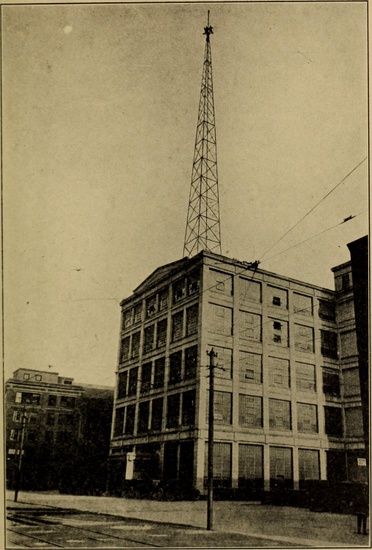
Fig 1: Radio tower, Schenectady, New York. From Frederick E. Drinker and James G. Lewis, Radio: Miracle of the Twentieth Century (Washington, DC: National Publishing, 1922), i. © Underwood & Underwood.
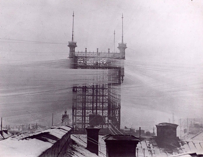
Fig 2: Stockholm telephone tower, circa 1890. Courtesy of Tekniska museet.
We might say that telecommunications’ topology of derricks and switches and wires and exchanges reflected a market epistemology—a way of knowing and activating the city to facilitate the dissemination and operationalization of business information and to satisfy new domestic and commercial telecom customers. Of course, this market-driven way of knowing the city isn’t new: the fact that the city has served as a mediated space of exchange—of goods and services and information—has long impacted its material form and its inhabitants’ lives.
New technologies exposed those inhabitants to new sensory experiences: new ways of listening in public, new ways of knowing their cities through sound. Brian Larkin writes about the arrival of colonial radio in Nigeria in the 1940s; loudspeakers installed outside the emirate council office, the public library, the post office, and other public places brought music and words, uttered in British accents, intended to win Nigerians over to the “power and promise of modern life.”6 For centuries, in the Islamic world, the call to prayer and, more recently, recorded sermons have resounded—mixing with the urban din, providing a means of spiritual orientation for the faithful, and, particularly in spiritually diverse cultures, inciting debates over spatial and sound politics. After centuries of dispute over the heights of minarets and the position of the muezzin who issues the call, some cities, responding to complaints of noise pollution, have decreed that those calls be broadcast via radio rather than cast into the urban air.
The urban infrastructures of telecom have proven themselves quite adaptable, retrofitable, for an Internet age and a terrain of connected devices. The new topologies of ethereal cellular communication and arrays of connected things still rely on networks of wires and poles and other material (often metal) gadgets. Our bodies can flow through the city streets with “seamless” coverage, never suffering a lost connection, because of a byzantine assemblage of hard-wired antennae bolted to rooftops and facades, knit together with millions of seams, beaming imperceptible but still very much material waves at all that populates the streets below. We inhabit a data space defined by various levels of intersecting protocols that direct our connections, facilitate or close off access, and thus subtly shape the geographies—both informational and physical—we are then able to explore.
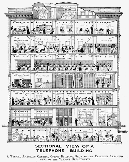
Fig 3: Sectional view of a telephone building, circa 1900. From Henry Chase Hill, The Wonder Book of Knowledge (New York: J. C. Winston, 1921).
Amid such indecipherable, proprietary, and even exploitative co-optations of the electromagnetic spectrum, we find some communities staking a claim to their own frequencies. While pirate radio was particularly prevalent in the 1960s, we see today, around the world, a resurgence of low-powered radio: resolutely local stations, often committed to homegrown music and to community news that, in conflict zones, become a lifeline. Even these informal broadcasts still rely on the city as an infrastructure. As Matthew Fuller writes of London’s tower blocks: “The thicker the forest of towers, the more antennae perched above the city, the more the Radiant City, botched, radiates.”7 In such “botched” cities, where so much of the world’s population lives, pirate radio sounds out the disjuncture, mismatch, time slippage, grafting, and hacking that characterize urban survival. The city might be “botched” or “broken up,” as Fuller says, but still, it resounds. Improvisatory resounding and listening constitute its way of knowing. Wired or unwired, concentrated or dispersed, smooth or striated, the media city hums as it has for millennia.
, YouTube, March 25, 2015. © VBS.IPTV.](https://d37vpt3xizf75m.cloudfront.net/api/file/u5r8Ks0SeewB2m3z4vVQ/convert?fit=max&h=550&w=700&compress=true&fit=max)
Fig 4: Rooftop pirate radio transmitters in London. Still from a short documentary by Palladium Boots for its Exploration film series. “London Pirate Radio”, YouTube, March 25, 2015. © VBS.IPTV.
Let’s turn back the clock. Whereas today some governing bodies find it more efficient and convenient to delegate the work of listening and decision-making to the machine—allowing an algorithm to impartially churn through the ethical and moral dimensions of governance—such matters of computation were once matters of deliberation or decree.8 Cities have historically provided space (either deliberately or accidentally) for the verbal articulations of democracy or dictatorship and for the vocal and bodily performances of public demonstration. Through archaeoacoustics, we can understand how ancient Athens’s law courts, stoas, and auditoriums, each with their own geometry and materiality, cultivated orators’ delivery and their audiences’ engagement. Even the philosophers’ “ideal city” itself often called for a particular infrastructure for the exchange of information: Aristotle prescribed a city that would contain no more people than could hear a herald’s voice. Archaeologists and classicists, in seeking to under- stand how the Roman forum functioned acoustically as a space for speech and pageantry, have acknowledged that their own ways of knowing these ancient cultures rely on much more than the verbal script, as did the ancients’ means of engaging with the content of a proclamation or a eulogy. These were multisensory affairs. The forum and other public spaces “created a formal tableau” that assigned status to different sensory experiences: the smells of bodies and food, the heat of the sun, the visual and textural cacophony of statuary, and the epigraphy that covered those public artworks and buildings.9
Despite both ancient and contemporary planners’ attempts to create cities as spaces of formal and visual order and acoustic harmony—spaces known through reason and rationality—we also know our cities to be terrains of cacophony and, at times, productive chaos. Voices of demonstration and collective dissent have long punctuated urban soundscapes, transforming streets and squares into resonance chambers for protest—places where counterepistemologies are produced. The particular material properties of those urban gathering spaces and their codes of operation also inform how collectives form and how voices are heard. Sites of infrastructural convergence are symbolically rich, often reinforcing the political messages of the people demonstrating there. But gatherings also often coalesce in underutilized, marginal spaces—terrains vagues—where, Saskia Sassen argues, threatened and otherwise “invisible” groups can “become present to themselves” and to others unlike them.10
In 2004, when the Nepalese civil war prohibited the public gathering of large groups of people, artist Ashmina Ranjit choreographed a procession of black- clad performers, directing them to walk silently in pairs through the streets of Kathmandu. In the procession, one member of each pair would drop to the ground in feigned death; the other would draw her outline in chalk. While the performers did not speak, some carried radios broadcasting cries and wails across all FM stations and the state-owned Radio Nepal: “Recorded and transmitted through the radio,” Laura Kunreuther explains, “the sounds of mourning”—“mothers’ sobs” symbolically lamenting the violence and loss in rural villages—“were transposed and remediated from their usual familial setting to a public, national one… The anonymity of crying became a means to create the sense and sensibility of public cohesion.” It was a cohesion built from the convergence of broadcast and architectural acoustic infrastructures.11
Jane Webster notes that “individuals at all levels of ancient Roman society”—including slaves—made literary and nonlinguistic figural inscriptions, both painted and carved, on the city’s surfaces.12 These inscriptions have long served to codify architectural functions, proclaim power, mark territory, evoke beliefs, profess allegiances, direct ritual, announce laws, and identify those who are welcome and unwelcome. The Islamic world has a particularly rich epigraphic tradition. “In a largely aniconic culture”—that is, one that forbids the creation of images of sentient beings—Yasser Tabbaa explains, “public inscriptions were by necessity one of the primary visual means of political and religious expression and one of the few ways for a dynasty to distinguish its reign from that of its predecessor.”13 The aesthetic properties of those public texts—their color, materiality, and form—have played a key role in how and what they communicate. These scripts function haptically rather than merely visually. For instance, the floriated Kufic script, sometimes ornamented with gold and glass mosaic, was “deliberately ambiguous”: it was both boldly visible and incomprehensible, seemingly inclusive and transparent but ultimately obfuscatory.14 This urban code was thus encrypted.
Roman and Islamic inscriptions—an early form of urban markup, we might say—were often encoded on the humblest of geological substrates. And today many urbanites have come to recognize that even their seemingly immaterial digital media are resolutely material—that their virtuality and seeming artificiality are dependent upon natural geologic components—copper, coltan, tungsten, silicon. Urban history manifests this entanglement: mud and its mate- rial analogues (clay, stone, brick, concrete) have supplied the foundations for human settlement and forms of symbolic communication, and they have bound together our media, urban, architectural, and environmental histories. Some of the first writing surfaces, clay and stone, were the same materials used to construct ancient city walls and buildings, whose facades also frequently served as substrates for written texts. The formal properties of those scripts—the shapes they took on their clay (or, eventually, parchment and paper) foundations— were also in some cases reflected in urban form: how the city molded itself from the materials of the landscape. Written documents have always been central to the operation of cities: their trade, accountancy, governance, and culture.

Fig 5: Epigraphy near the Qalawun complex, Cairo, 2009. Photograph by Christopher Rose.
Think of all the other print-based forms of urban media that embody urban epistemologies and that “program” the material city: newspapers and their columns; filing cabinets and the enormous file of the skyscraper itself; early architectural treatises and their prescription of particular, repeatable spatial forms; “legible” building facades and urban forms; and libraries full of books. These media represent entire chapters of technological and urban history that we simply don’t have time to explore here—but they, too, profoundly impact the way cities are designed, built, administered, experienced, and understood. We’ve been predicting a paperless era for decades, but print is still here: independent book- stores are experiencing a renaissance, our cities host vibrant niche publishing cultures, and the exchange and display of print materials in public spaces affords many urban dwellers a means of carving out a commons amid increasing corporatization and “platformization.”
As we focus increasingly on digital and data-driven media technologies, it’s important to recognize that cuneiform tablets and epigraphy are data too. That the old and the analog are still present and active. They are, as Raymond Williams explains, “residual”: “formed in the past but still active in the cultural process, not only and often not at all as an element of the past, but as an effective element of the present.”15 We’re still talking and listening and reading and writing and print- ing and filing. Our cities, past and present, mediate between various manifestations of intelligence—legal codes and copper cables, inscriptions and imaginaries, algorithms and acoustics, public proclamations and system protocols. They’re both old and new, clay and code. A city that knows its dependence on both ether and ore is better equipped to accommodate temporal entanglement and epistemological plurality. And more capacious, historically attuned ways of knowing our cities—and of generating and operationalizing urban intelligences—produce cities that are ultimately much smarter, or wiser, than the sum of their intelligent parts.
SHANNON MATTERN is a professor at the New School for Social Research. She is the author of Code and Clay, Data and Dirt (University of Minnesota Press, 2018), The New Downtown Library: Designing with Communities (University of Minnesota Press, 2017), and Deep Mapping the Media City (University of Minnesota Press, 2015). She also contributes a regular long-form column about urban data and mediated infrastructures to Places Journal. You can find her at wordsinspace.net.
This essay was adapted from Shannon Mattern, Code and Clay, Data and Dirt: 5000 Years of Urban Media (Minneapolis: University of Minnesota Press, 2017); Portions were originally published as “Of Mud, Media, and the Metropolis: Aggregating Histories of Writing and Urbanization,” in Cultural Politics 12, no. 3 (2016): 310–331. © Duke University Press. All rights reserved. Republished by permission of the copyright holder, Duke University Press.
This paragraph is adapted from Shannon Mattern, Code and Clay, Data and Dirt: 5000 Years of Urban Media (Minneapolis: University of Minnesota Press, 2017), xi.
I draw here on the description of the conference that inspired this volume of essays: “Ways of Knowing Cities,” Columbia University, February 9, 2018, https://www.arch.columbia.edu/events/816-ways-of-knowing-cities.
Mattern, Code and Clay, xxiv.
Much of the next seven paragraphs is adapted from Mattern, Code and Clay, chapter 1.
Emily Bills, “Connecting Lines: La’s Telephone History and the Binding of the Region,” Southern California Quarterly 91, no. 1 (Spring 2009): 28.
Brian Larkin, Signal and Noise: Media, Infrastructure, and Urban Culture in Nigeria (Durham, nC: Duke University Press, 2008), 50.
Matthew Fuller, Media Ecologies: Materialist Energies in Art and Technoculture (Cambridge, Ma: MIT Press, 2005), 15–16.
Much of this paragraph and the next is adapted from Mattern, Code and Clay, chapter 4.
Diane Favro and Christopher Johanson, “Death in Motion: Funeral Processions in the Roman Forum,” Journal of the Society of Architectural Historians 69, no. 1 (March 2010): 15.
Saskia Sassen, “Does the City Have Speech?,” Public Culture 25, no. 2 (April 2013): 217.
Laura Kunreuther, “Democratic Soundscapes,” Avery Review 21 (January 2017), http://averyreview.com/issues/21/democratic-soundscapes.
Jane Webster, “Less Beloved: Roman Archaeology, Slavery, and the Failure to Compare,” Archaeological Dialogues 15 (June 2008): 118. Much of this paragraph and the next is drawn from Mattern, Code and Clay, chapter 3.
Yasser Tabbaa, The Transformation of Islamic Art during the Sunni Revival (Seattle: University of Washington Press, 2001), 54.
Yasser Tabbaa, “Review of Islamic Inscriptions by Sheila S. Blair; Writing Signs: The Fatimid Public Text by Irene A. Bierman; Islamic Ornament by Eva Baer,” Ars Orientalis 29 (1999): 182.
Raymond Williams, Marxism and Literature (New York: Oxford University Press, 1977), 122.
8
Data Driven: Managing Care and Dis(re)membering in the Knowing City
9
Right to the Smart City: How to Represent, Resist, or Disappear
Borders
10
Minding the Gaps: Navigating Absences in the Zimbabwean Imaginaries
11
Tracing the Diasporic Experience through the African Hair Braiding Salon
12
A War on Mobility: The Border Empire Strikes Back?
We are familiar with expressions such as “a war on drugs” and “a war on terror,” but what about “a war on mobility”? Is anyone speaking about the realities of our world in this way? It is time to popularize a radical twist in the discourse and perception of international migration and the ways it is currently dealt with. This essay builds on the idea of a war on mobility, interrogating migration through the “war” being waged against it and through the territorial technologies exporting borders and monitoring movement into the European Union.
THE BORDER EMPIRE GOES GLOBAL
Migration control increasingly takes place beyond the borders of destination countries.1 Migrants’ journeys are traced using advanced technology and paramilitary deployments that target their supposed places of origin and possible routes of transit. The United States, the European Union, and Australia have increasingly displaced their respective border controls farther away from national limits, under the assumption that these countries are the destination for most migrants.
During the recent “refugee crisis,” the European Union increased its bilateral agreements with “third,” or non-EU, countries for the containment of migration flows—strengthening collaboration on border patrol, surveillance, and interception. These border cooperation projects between destination-transit-origin countries are fundamentally changing the spatial imaginaries and realities of borders and the practices used to maintain and enforce them. EUROSUR, the European Border Surveillance System, has begun to reinforce near-real-time data sharing on border movements through national coordination centers in EU member states and partner countries. To support these efforts, Frontex (a body that coordinates border management across and between EU countries), European national border guards, and independent think tanks, such as the International Centre for Migration Policy Development (ICMPD), are providing technical and training support to countries at and beyond the external frontiers of Europe.
These border policies, which involve acting beyond territorial lines and in coordination with third countries, constitute an approach to migration management called “border externalization.” Externalization has become the predominant migration control policy in the European Union, implementing border work far beyond national borderlines. As a system for managing mobility, externalization coordinates tactics and cooperations at various scales—from retraining police and border forces and exporting biometric technology for national ID cards to intervening in third countries through paramilitary operations. Externalization not only outsources border work, meaning that a country, or group of countries, requests or coerces another country to police migration, as we have seen in the European Union’s financing of Morocco to police both Moroccan emigration and African immigrants in Morocco who may (or may not) be en route to EU countries; it also establishes the ability of border and migration enforcement institutions of one country to intervene in another. Take, for instance, the joint coastal and land patrols developed between Spanish and Mauretanian or Spanish and Senegalese border institutions.
Border externalization fits with recent theoretical considerations on “moving borders,” signaling how border work is not limited to the border itself or to traditional checkpoints but rather is constantly mobile, adjusting to migrants’ ever-changing itineraries. Besides the impact on human life, critics have denounced the legality of stretching the border in this way and externalization’s tendency to evade international law and national jurisdictions. While externalization has been expanding in recent years, its practices have a longer history. In fact, a genealogy of externalization can be traced as far back as the slave trade and slave suppression efforts, and to early attempts at imposing visa requirements prior to travel or carrier sanctions, both dating back more than a hundred years. A more contemporary outsourcing of border control has roots in the United States’ interdiction of Haitian refugees in the early 1980s.2
The conventional understanding of migration control has been that each nation-state is in charge of its own borders at territorial lines and through visa applications in national embassies abroad. However, this traditional approach is considered incomplete among EU migration-policy circles. “Efficient migration management” requires that a nation-state goes beyond the place and time of the entry point. Transnational cooperation makes it possible to track exactly where the migrant is and is ostensibly going. This system of remote control, the off-shoring and outsourcing of borders, aims at tracing and managing the entirety of the migration journey.3 Externalization thus manifests the spatial logics of a global strategy of mobility control. This is how “migratory routes management”—which was first expressed by the European Union in the Global Approach to Migration and Mobility in 2005 and which aims to track and intervene in migrants’ trajectories throughout their journeys—has become a migration management concept and strategy.4
Enacting migratory routes management as a strategy, though, requires both important shifts in how and where the border is imagined and implemented and the identification of countries needed to operationalize this strategy. To this end, externalization has also entailed new spatial thinking and vocabulary (such as the “migratory route” as an object of management) as well as new cartographies that aid in visualizing the space of the border anew. The generation and deployment of data in relation to international mobility provides an impressive number of figures, statistics, and representations about human flows, many of which are visualized as maps of migratory flow and direction. In fact, migration maps are key to current migratory policies. These institutional cartographies chart entire migratory journeys (or purport to)—identifying potential points of control far beyond any given country’s territorial limits—and thus signal both border externalization’s neo-imperial pretensions and its social impact on cities within and outside the European Union.
. Courtesy of ICMPD.](https://d37vpt3xizf75m.cloudfront.net/api/file/KxPwpTX3RSiHcFHVSb1W/convert?fit=max&h=550&w=700&compress=true&fit=max)
Fig 1: The i-Map, or the interactive map on migration, portrays global itineraries or migratory routes. Produced by the International Centre for Migration Policy Development, Vienna, 2012–ongoing. This is a static visualization of the migration routes published by the ICMPD in 2014. The most recent version of the i-Map is accessible only with a username and password. You can request access here. Courtesy of ICMPD.
The i-Map project, produced and managed by the International Centre for Migration Policy Development, is an important example of this attempt to reimagine the externalized border. The i-Map constitutes a thick visual archive of migratory movements presumably toward Europe. Since 2006 different versions of the i-Map (some more interactive and more detailed than others) have been available online. The i-Map clusters itineraries along major routes—indicated by thickened color lines—representing the common paths thought to be taken by irregular migrants from different locations. The map visualizes itineraries by linking “hubs” and “sub-hubs,” such as cities or neighborhoods, mentioned in police interrogations with irregular migrants. Each hub has a hyperlink (not accessible to the public) with risk assessment information developed by Frontex, along with the European Union Agency for Law Enforcement Cooperation (better known as EUROPOL) and the United Nations Office on Drugs and Crime. These route lines are the predominant feature of the map, as opposed to national borderlines. By representing the entire route one travels, and thus visualizing the route as a transnational geopolitical concern, the i-Map constructs new forms of illegality, targeting border crossing before any border is crossed—making people illegal at the very time and place they decide to migrate.5
The European Union and its member states have instituted border policies that attempt to manage or limit migration long before a migrant arrives at or near official EU borders. One such series of operations is Operation Seahorse, coordinated by Spain in North and Western Africa and funded by the European Union.

Fig 2: Operation Seahorse, as visualized by Spanish border authorities. PowerPoint by Servicio Fiscal y de Fronteras de la Guardia Civil, “Slide on System Architecture,” Madrid, 2013. Courtesy of the Spanish Civil Guard.
Operation Seahorse established relations with border and coast guard authorities between multiple West African and EU countries with Spain acting as the primary mediator. These relations included conducting trainings, distributing equipment, and negotiating and conducting joint border patrols.6 These were not simply one-off exchanges but rather multiyear police cooperation missions requiring new infrastructures and protocols to facilitate them. “System architecture” is one way the Spanish Civil Guard’s border unit refers to the material buildings and technological support needed to operate these new border control projects (see figure 2). Multiple communication and control points across cooperating countries are articulated by two central nodes in Madrid and the Canary Islands (each box in figure 2). Although spanning five countries, this apparatus is considered one border architecture. According to Spanish police representatives, one of the key factors determining the success of these operations is the regular joint patrols consisting of coast guard forces from different countries (Cape Verdean/Portuguese, Mauretanian/Spanish, Senegalese/Italian, and Senegalese/Spanish) along the West African coast (see figure 3). One can’t help but wonder why such a robust transnational police and military framework—with its corresponding political and technological infrastructures—is necessary to detain wooden boats filled with low-income or unemployed fishers. Regardless of the motives, the efficacy, or the human consequences of border externalization, these emerging practices of migration control deeply reconceptualize border architectures.
EUROCENTRIC VISION OF MOBILITY?
While we were working on the lineage of the current EU migration regime, a controversial official document, by the EU Commission, proposing to divide the world into concentric circles caught our attention: the “Strategy Paper on Immigration and Asylum Policy.”7 The geographic imaginary in this document underpins the extraterritorial operations of Operation Seahorse; and it is a geographic imaginary that is fraught, literally, with Euro(con)centric tensions.8
During the Austrian presidency of the European Union in 1998, a geographical vision of managing mobility into Europe scandalized EU authorities. Perceived as an unnecessarily restrictive and discriminatory approach to migration, the official document released to the EU commission and council evoked a clear though rigid understanding of how mobility should be distributed in the world. This 1998 document classified worldwide territories and populations therein into four concentric circles. It mapped an idea of the world where everyone, in a sense, belongs and should remain in their respective circle, with few exceptions. Such a geographical imaginary centers the European Union and dictates who should move and who should not move around the world. Despite its rather Eurocentric and hierarchical approach toward human mobility, this managerial vision underpins current EU migration policy, especially its border outsourcing practices.
Fig 3: Operation Hera, as visualized by Spanish border authorities. PowerPoint by Servicio Fiscal y de Fronteras de la Guardia Civil, “Slide on Stop Operations,” Madrid, 2013. Courtesy of the Spanish Civil Guard.
The policy itself was officially voted down in 1998, though some of its ideas were further pursued by the High-Level Working Group on Migration (HLWG) and individual member states of the European Union.9 Slowly but surely this spatial vision has become an informal organizing framework for EU policy on migration management and the basis of restrictive migratory policies. This vision and its mapping of the world have not been fully achieved on the ground: plans and projects were tried; some succeeded, some failed. This is not a representation of the EU border regime as it actually exists. Yet the designation of spaces of the world beyond the European Union and their role in migration systems and border policy have, for the most part, remained intact.
As explicitly stated in the document, the goal was to go “global” and to replace the model of “fortress Europe.” In this globalization of borders, mobilities were instead categorized and confined to four zones according to certain criteria. The 1998 document clearly designates zones of the planet where permissible or less permissible human movement occurs. Entire groups of countries are slated as “secure” in their borders or as sources of problematic emigration, and yet the factors leading to any of these designations (accurate or not) are ignored. The first zone, represented as a circle, is formed by the EU member states, capable of fulfilling Schengen standards of control, and other countries that “do not cause emigration” but have become “target countries on account of their advanced economic and political situation.”10
Fig 4: A cartographic visualization of the EU Commission’s “Strategy Paper on Immigration and Asylum Policy,” a proposal toward inward migration presented during the Austrian EU presidency in 1998. “The Four Concentric Circles of Mobility,” 2018. Circle 1 marks the desirable destinations and zones of mobility; Circle 2 highlights countries adjacent to the European Union considered almost as rest zones in the migrants’ itineraries; Circle 3 highlights countries far away from the European Union but still considered “transit zones”; Circle 4 highlights countries considered as sources of population flows (the yellow stars reveal sites identified by Frontex as current sources of illegal migration). Courtesy of Tim Stallman.
The second zone consists of “transit countries,” which no longer generate emigration but “on account of a relatively stable internal economic and political situation accept only very limited control procedures and responsibility for migration policy.” This circle comprises countries neighboring the Schengen/EU territory that have signed some form of association agreement with the bloc and “perhaps also the Mediterranean area.” According to the report, these countries’ systems of control should gradually be brought into line with the first-circle standards.11
The third zone is characterized by countries of both emigration and transit—that is, the Commonwealth of Independent States (CIS) area (the former Soviet Union), Turkey, and North Africa. These countries would be required to “concentrate primarily on transit checks and combatting facilitator [migrant smuggler] networks.”
The fourth (outermost) zone is made up of countries of emigration apparently deemed beyond the reach of European “political muscle” (it mentions “the Middle East,” China, and “black Africa”). These countries are encouraged to “eliminate push factors” of migration.12
The EU Commission’s “Strategy Paper on Immigration and Asylum Policy” outlined a reward system for controlling, policing, and curbing migration—incentivizing a country to meet the obligations of its particular circle and assignment: “For example, the second circle must meet Schengen standards as a precondition for EU membership; for the third circle, intensified economic cooperation is linked to the fulfillment of their obligations; and the fourth circle, the extent of development aid can be assessed on that basis.”13 These maps make graphically explicit what many of us take for granted in our critiques: a problematic Eurocentric vision of migration.
This highly hierarchical and racialized Euro(con)centric vision of mobility contains several assumptions that, while problematic, persist: first, everybody intends to get to circle 1 (ignoring movement within and across circles—that is, South to South migration); second, nobody gets out of the European Union, and there is no movement from circle 1 to circles 2, 3, or 4 (ignoring increasing numbers of EU citizens fleeing the austerity crisis); third, circle 1 should command who moves where; and fourth, partner countries in circles 2, 3, and 4 have no other goals or approaches to the management of mobility. In this vision, a center assigns particular roles to distinct regions of the world for both producing and managing mobility. Individual governments are expected to control their own citizens—carrying out border control in certain ways and instituting specific regulations about how and where their populations can move.
Outraged by this vision of control and its Eurocentric assumptions, we have tried to share this research with broader audiences through exhibitions showcasing the numerous cartographies produced by border authorities—and migratory maps rarely available to the public—alongside our own representations of the problematic geographic imaginary embedded in EU migratory policy documents.14 We decided to revisualize the European Union’s geographical imaginary as a series of maps, in the hope that a compelling counternarrative about migration might become clear: that the proclaimed “problem” of migration is not about troublemakers from poor countries in the South fleeing in a massive exodus toward the United States and the European Union, changing the face of the world. This dusty EU policy document turns taken-for-granted assumptions of migration control upside down: the problem does not rely on those who are moving. Rather, the concern is the attempt to impose a scary plan to control human mobility worldwide.

Fig 5: The exhibition It Is Obvious from the Map, at REDCAT, Los Angeles, 2017. Courtesy of Sohrab Mohebbi and Thomas Keenan.
While institutional migration maps deploy a certain professionalism and neutrality associated with expertise, they are driven by a restrictive logic of containment. Our maps, on the other hand, are the product of embodied, experiential, and activist knowledge(s) coming from those supporting and enacting a politics of freedom of movement. The examples of countercartographies show how controversial, problematic, and inaccurate institutional maps for migration control are. These countermaps enable alternative visions and practices of human mobility.15
“EMPIRE” TIMES
Border externalization appears to reproduce the colonial logic of “ordering” territories and populations, one that dates from the high imperialism of the late nineteenth century. Direct intervention on the part of the European Union in places of supposed origin and transit of migrant trajectories—through development projects, the creation of civil registry databases, international military deployments, or foreign police operations—has led to critical readings of externalization and border cooperation as a form of neocolonialism.16 Processes of externalization imply more than a rollout of imperial power, if the agency of African nation-states, with their diverse and at times divergent reasons for participating in border cooperation with the European Union, is also taken into account.17
In the i-Map, Europe-bound migrations are represented in flashy migratory routes that erase African national borders. This is reminiscent of the boundary-making power that Europeans have historically exerted on the African continent since colonial times. This geographic imaginary embraced by the European Union and its member states portrays a displaced border space, which ignores and overrides African nation-state borders.18 That imagining only makes sense in the historical context of a colonial erasure of previously existing polities and societies. Again, Africa becomes a kind of living space for Europe to design, order, and profit from.19 In fact, we can see border externalization as the next chapter in the story told by migration and citizenship scholar Seyla Benhabib. In her writings on postcolonial migration, Benhabib observes:
This legacy of empire has come back today to haunt the [rich] countries of the Northern Hemisphere through the rise of transnational migrations. Transnational migrations also produce an uncoupling between territoriality, sovereignty, and citizenship but in ways quite different than colonialism. Whereas in the nineteenth and twentieth centuries, European imperialism spread forms of jurisdiction into colonial territories, which were shielded from democratic consent and control, contemporary migratory movements give rise to overlapping jurisdictions which are often protected by international norms… The Westphalian state which extended towards the rest of the world now finds that its borders are porous in both directions and that it is not only the center which flows to the periphery but the periphery which flows towards the center.20

Fig 6: The exhibition Signs and Whispers, at Galeria Nova, Zagreb, 2018. Courtesy of the What, How, and for Whom Collective.
The center again flows to the periphery in its attempts to border the same transnational migrations that emerged, at least in part, from the postcolonial condition. While migration may produce an “uncoupling between territoriality, sovereignty, and citizenship,” shifting border policy is also contributing to this “uncoupling” in distinct ways. National affiliations based on exclusive loyalty to a single sovereign state have been shaken by international migration flows. With border externalization processes, “whose” border is “where” is also thrown into question. Confusion emerges in cases where, for example, a Spanish Gendarmerie officer intercepts someone in Senegalese waters. If that person claims asylum, which country must process that claim? Spain or Senegal? Overlapping jurisdictions undercut accountability, international norms, and human rights legislation.
THE BORDER EMPIRE TARGETS CITIES
While many studies of externalization focus on understanding its geopolitics and the transformations it entails in relation to law, sovereignty, and human rights, the urban dimension of externalization is often overlooked. What are the implications of externalization at the urban scale? While news headlines may focus on fences, coast guard patrols, or even desert traversals, metropolis and minor urban settlements have become a priority in the European Union’s agenda for containing migratory flows. For remote border control, cities are considered hubs that facilitate human mobility. This is explicit in the migration routes management strategy and in the i-Map, which draws the route by connecting different cities and towns where migrants are thought to have traversed. Thus the route to be managed is a string of cities understood as migratory hubs. Depending on the time and the city along a route, border practices might include the facilitation of development projects that bring stable employment opportunities to those places; increasing police raids and the number of checkpoints asking for ID; or the rise of independent transportation services among different towns for deporting people. Given that routes and migration may shift over time, partly in response to externalization measures, the “hubs” or cities affected and how they are affected will change. All these practices constitute processes for making someone’s movement undesirable and ultimately coded as “illegal.” This production of illegal mobilities is unfolding ubiquitously, regardless of place, although it is occurring with increasing frequency and intensity at the urban scale.
These bordering practices have tangible effects on the urban fabric of cities where externalization is carried out. The city, in addition to its role in facilitating mobility through transportation infrastructures and facilities, becomes simultaneously antagonistic to mobility. This antagonism becomes apparent when the city serves as a site for increased police patrols, new policing equipment, the rolling out of ID cards for residents, EU-funded propaganda and billboards dissuading irregular migration, and even new buildings to house the International Organization for Migration and other migration-related bodies (who, at times, have become significant employers in the city). The urban landscape is thus transformed through this migration industry, or what anthropologist Ruben Anderson calls the “Illegality Industry.”21 In some cases, such as in Rabat (Morocco) and Nouadhibou (Mauretania), these transformations have led to increasingly segregated migrant landscapes. The pursuit of people who “might” be on their way to Europe and the adoption of restrictive migration policies by host African countries cooperating with externalization efforts are contributing to rising patterns of discrimination and ghettoization in places where these dynamics of urban spatial segregation were historically less frequent. This can occur through the stripping of legal residency from intra-African migrants and increased police attention toward those same migrant communities.
BORDERWARS AND ITS FRACTAL TECHNOLOGIES
In recapitulating externalization policies and their impact on cities, we offer a theorization of the mobility of borders and its underlying imperial politics of controlling (certain) people on the move. For this, we start by reciting the evocative statement “We did not cross the border, the border crossed us,” which has become a rallying call for pro-migration activism beyond the US–Mexico context where it was originally voiced.22 While counterintuitive, it points to the historical and ongoing contingent itinerancy of borderlines. It also speaks about the ingrained discriminatory character of a border mindset that believes that one’s very self can be permanently marked as “border crosser” and thus “intruder,” an inappropriate and usually undesired other.23
While border crossing constitutes a hot policy and scholarly concern, borders themselves are actively “crossing” over people, regardless of their geographical locations and kinship. Borders—as institutionalized practices of containing, filtering, and ordering populations—do not just take place at the territorial limits of countries. In fact, the act of arranging people into hierarchies of mobility is becoming a ubiquitous process and reality wherever one is. Thus, the message conveyed by “the border crossed us” uniquely captures the goal of current migratory policies and the ever-reaching regime of mobility control. In its pervasiveness, all of us are potential targets to be crossed by endless sets of reproducible borders. Both the imagination and the enforcement of migration control are intended to “cross”—as in traverse through—populations. This crossing by borders is conducted through the arbitrary containment, classification, and segregation of people who are both in place and on the move.24
Furthermore, borders are crossing territories far beyond the borderlines they supposedly contain. On the one hand, growing public budgets are subsidizing high-tech infrastructures for the tracking and interception of human movements at and beyond the borderline (such as with contraction of fences and externalization missions). On the other hand, institutionalized practices toward the bordering of bodies are taking place at and within the borderline through the proliferation of checkpoints inside the destination countries (the cross-checking of migration status with databases for other services like banking, driving, medical care, etc., and migrant detention). All of those practices within receiving countries speak to a parallel process of “border internalization.” This double process points to a growing normalization and institutionalization of border work regardless of location, which, in turn, leads to concerning levels of racialized profiling, random incarceration, abuse during interrogation, and deportation. The question of mobility is further complicated when we consider populations and groups of migrants who have managed to enter into the European Union. As Martina Tazzioli and Claudia Aradau have argued, it is the settlement of refugees in EU cities that becomes the target of prohibition, meaning that mobility, in turn, becomes a weapon of displacement and precarity used to keep migrants constantly on the move.
We propose to embrace this twist in our understanding of borders: from stable lines to be crossed to institutional practices actively “b/ordering” populations in an endless war on mobility.25 That is, borders as actively and consistently crossing us to the point that they dictate political allegiances, our corresponding entitlements, or lack thereof. Seen in this way, the powerful yet normalized device of mandatory membership and social stratification—the national border—would scandalize many, regardless of ideological position. The rigid control of human movement into, out of, and within countries has often been associated with dictatorships attempting to maintain control within their despotic limits. Culturally, for many people, the control of people’s movements—interrupting journeys and interrogating destinations and points of transit—is not well taken. People want to get through airport security quickly, travel for summer vacation, avoid traffic jams. Seen at this abstract level, the freedom of movement can be seen as a shared value regardless of political dis- agreements. Legally speaking, the ius migrandi (right to migrate) was codified in a protocol by the League of Nations in 1929, amid calls by the same international organization to abolish passports.26 In fact, article 13 of the 1948 Universal Declaration of Human Rights, which established the right to emigrate, is merely an abridged version of the 1929 protocol. The rest of that protocol—that is, both the right to immigrate and the right to reside—was lost in the context of the Great Depression, World War II, and the emerging Cold War. Thus, our current world order keeps actively disregarding this deeply held cultural value and its tradition in international law to focus instead on a ferocious and publicly funded control of international mobility.
This questionable way of dealing with people and their movements is not only felt at the customs line (who gets fingerprinted and iris-scanned, who gets sent to the “interrogation room,” who moves through the faster lines for citizens or Global Entry, etc.). Borders are reproducing in a fractal way, implementing their b/ordering logic of social control in unexpected ways and generating a controlled space with no outside. Fractals are patterns that are similar across different scales. Fractals are generated by repeating a simple process over and over again. Border fractals are thus a series of checkpoints, made out of smaller checkpoints, which are made out of even smaller checkpoints (border walls to visa regimes to databases cross-checking migration status, and so on). In the core of assumed destination or host countries, particularly in their cities, these fractals are reproduced through migrant detention, Immigration and Customs Enforcement (ICE) raids, and threats to employees using Social Security numbers that may not match the Social Security Administration records—a continuous pattern of contention, displacement, and stratification that is ever present and can seem invincible. With externalization this fractal pattern spreads its work thousands of kilometers away from legal borderlines, where, for example, the “successful” (in police terms) monitoring of Spanish and Moroccan coasts is moved to similar processes of patrolling in West African waters, which is then followed by a move to conduct land border control in countries like Mali and Niger. In these efforts, urban nodes of transport become points for intervention. Port cities (like Agadir in Morocco or St. Louis in Senegal) become sites where all boats must be registered, all license numbers cross-checked with migration authorities, and all fuel sales registered with local police. Bus stations in cities like Agadez become surveilled sites with police impounding any vehicle believed to be used for transporting potential migrants. The borderline has moved both inward and outward of the territorial state’s limits. The border empire is every- where, or rather potentially anywhere. Such a spatial proliferation of bordering practices materializes a regime of mobility control that would scare anyone if it were the subject of the latest action movie: BorderWars, anyone?
BORDERS ADRIFT
Borders are on the move. This itinerant character might look similar to a Situationist “drift” at first glance, but it is not the itinerancy envisioned by the open-ended method of the drift. In stark contrast, these borders in motion follow orders from a center, ruled by experts and followed by military agencies. A political will lies behind border drifting: the desire to control human mobility.
The politics driving current migration management is encapsulated in a text message sent by a sub-Saharan migrant who tried to swim the fifteen kilometers between the African and the European continents through the Strait of Gibraltar: “There is an ongoing war on migrants.”27 A few decades ago, a regular ID would have been enough to enjoy a safe trip by ferry from Africa to southern Spain, but now he and many others are prohibited from ferry travel and must embark on the more treacherous South-to-North route. This war on mobility is spatially and culturally infecting the globe. Given the displacement of migratory control practices from national lines to points along the migratory journeys, following and incriminating migrants from beginning to end, the war against mobility has become global: urban and not urban; in centers and peripheries, mobilizing both space and time. In this scenario of borders “drifting,” where are the members of the “resistance” to such a border empire? We want to believe that resistance is also everywhere. Indeed, those moving regardless of administrative paperwork, zigzagging in unexpected motions, embody the ongoing challenge to the ubiquitous presence of the border regime. Still—and this question is yet to be explored—how does one position oneself outside and against this war on mobility?
Thanks to Sohrab Mohebbi and Thomas Keenan, curators of the exhibition It Is Obvious from the Map, presented at the Los Angeles–based art gallery REDCAT. We value their passionate interest in the EU border regime and their pursuit of making its intricacies accessible to the broader public. Also, we highly appreciate the advice of REDCAT’s editor, Jessica Loudis, who carefully reviewed the original version of this text to make it as clear as possible. Finally, thanks to cartographer Tim Stallman for working with us to visualize the geographic thinking behind some of the key EU documents defining current migration policy. Last but not least, thanks to all of those who keep moving across borders, with or without required paperwork, for challenging the current border system.
MARIBEL CASAS-CORTÉS is an interdisciplinary scholar working at the intersection of border studies, cultural analysis, and critical theory. She was recently awarded a research position in Spain following a Hunt Fellowship, which enabled her to work on a monograph on social movements and precarity in southern Europe, affiliated with the University of North Carolina at Charlotte. She holds a PhD in cultural anthropology from the University of North Carolina at Chapel Hill and has published in journals such as Citizenship Studies, Rethinking Marxism, Cultural Studies, and Anthropology Quarterly.
SEBASTIAN COBARRUBIAS is currently an ARAID research professor in the Geography Department at the University of Zaragoza, Spain. His research interests include border studies, social movements, and critical cartographic theory. He holds a PhD in human geography from the University of North Carolina at Chapel Hill and has published in journals such as Antipode, Political Geography, and European and Urban Regional Studies.
This section is based on our multisited research project on “Border Externalization by the EU,” funded by the National Science Foundation 2010–2014. We also draw from the graphics we gathered for the exhibition It Is Obvious from the Map, curated by Thomas Keenan and Sohrab Mohebbi in Los Angeles and Zagreb.
For more on this, see “New Keywords: Migration and Borders,” which is a collaborative publication produced by more than a dozen migration and border studies scholars that consists of key concepts in current research and that establishes the parameters of a common language in critical migration and border studies. Maribel Casas-Cortés et al., “New Keywords: Migration and Borders,” Cultural Studies 29, no. 1 (2014): 55–87.
Aristide Zolberg, “The Archeology of ‘Remote Control,’” in Migration Control in the North Atlantic World: The Evolution of State Practices in Europe and the United States, ed. Andreas Fahrmeir (New York: Berghahn Books, 2003), 195–223; Ruben Zaiotti, ed., Externalizing Migration Management: Europe, North America and the Spread of “Remote Control” Practices, Routledge Research in Place, Space and Politics (New York: Routledge, 2016); Luiza Bialasiewicz, “Off-Shoring and Out-Sourcing the Borders of Europe: Libya and EU Border Work in the Mediterranean,” Geopolitics 17, no. 4 (2012): 843–866.
Maribel Casas-Cortés, Sebastian Cobarrubias, and John Pickles, “Riding Routes and Itinerant Borders: Autonomy of Migration and Border Externalization,” Antipode 47, no. 4 (2015): 894–914.
Maribel Casas-Cortés, Sebastian Cobarrubias, and John Pickles, “B/Ordering Turbulence beyond Europe: Expert Knowledge in the Management of Human Mobility,” in Mapping Migration, Identity, and Space, ed. Tabea Linhard and Timothy Parsons (Cham, Switzerland: Palgrave Macmillan, 2019), 257–281; Sebastian Cobarrubias, “The i-Map and the Cartopolitics of ‘Migration Mangement’ at a Distance,” Antipode 51, no. 3 (2019): 770–794.
Figures 2 and 3 are from PowerPoints used by the Spanish Civil Guard. These presentations demonstrate the rationale of externalization as well as how the border is imagined spatially in this type of border operation.
Council of the European Union, “Strategy Paper on Immigration and Asylum Policy, from the Austrian Council Presidency to the K4 Committee,” 1.7.98, 9809/98 CK4 27, ASIM 170, limite (1998), http://archiv.proasyl.de/texte/europe/eu-a-o.htm. Note: This refers to the initial leaked draft. Subsequent drafts have the following codification: 9809/1/98, Rev 1 Limite, CK4 27, aSIM 170; and 9809/2/98, Rev 2 Limite, CK4 27, ASIM170.
A detailed study of this EU document can be found in our piece, “Concentric Circles in the EU’s External Migration Policy? Dissecting Colonial Logics in the Ordering of Territories and Mobilities,” in The Critical Handbook on Migration Geographies, ed. Kathryne Mitchell, Reece Jones, and Jennifer Fluri (London: Edgar Ellen, 2019), 193–205.
The HLWG was set up at the end of 1998 as part of an initiative of the Netherlands, which was president of the EU at the time. The HLWG is a strategic analysis group with representatives from various member states tasked with drafting “action plans” on migration and border policy vis-à-vis non-EU countries. It was under the auspices of this group that the strategy paper continued to have influence in official circles.
Council of the European Union, “Strategy Paper on Immigration and Asylum Policy” (points 60 and 116).
Council of the European Union, “Strategy Paper on Immigration and Asylum Policy” (points 60 and 118).
Council of the European Union, “Strategy Paper on Immigration and Asylum Policy” (points 60 and 119).
Council of the European Union, “Strategy Paper on Immigration and Asylum Policy” (point 61).
For more information, visit REDCAT, https://www.redcat.org/exhibition/it-obvious-map, and Galeria Nova, http://www.whw.hr/galerija-nova/izlozba-signs-and-whispers.html.
Many of these maps are now part of the itinerant art collection first launched in Los Angeles and later hosted in Zagreb: It Is Obvious from the Map! Maribel Casas-Cortés and Sebastian Cobarrubias, “‘It Is Obvious from the Map!’: Disobeying the Production of Illegality beyond Borderlines,” Movements: Journal für kritische Migrations und Grenzregimeforschung 4, no.1 (January 2018): 29–44.
Mark Akkerman, Expanding the Fortress: The Policies, the Profiteers and the People Shaped by EU’s Externalisation Programme (Amsterdam: Transnational Institute, 2018); Sara Prestianni, “The Dangerous Link between Migration, Development, and Security for the Externalisation of Borders in Africa” (Rome: ARCI Reports, 2018), https://www.arci.it/documento/ the-dangerous-link-between-migration-development- and-security-for-the-externalisation-of-borders-in-africa-case-studies-on-sudan-niger-and-tunisia; Tony Bunyan, “Analysis: The EU Goes to War with African ‘Elite,’” StateWatch Bulletin, 2016.
Paolo Gaibazzi, Stephan Dünnwald, and Alice Bellagamba, EurAfrican Borders and Migration Management: Political Cultures, Contested Spaces, and Ordinary Lives (New York: Palgrave Macmillan, 2017).
This erasure of African national borders is far from the call to “scrap the borders” that Achille Mbembe makes in a recent impassioned plea: “The next phase of Africa’s decolonisation is about granting mobility to all her people and reshaping the terms of membership in a political and cultural ensemble that is not confined to the nation-state.” Freedom of movement within Africa becomes a “cornerstone of a new pan-African agenda”: “To become a vast area of freedom of movement is arguably the biggest challenge Africa faces in the 21st century. The future of Africa does not depend on restrictive immigration policies and the militarisation of borders.” Achille Mbembe, “Scrap the Borders that Divide Africans,” Mail & Guardian, March 17, 2017, https://mg.co.za/article/2017-03-17-00-scrap-the-borders-that-divide-africans.
Peo Hansen and Stefan Jonsson, Eurafrica: The Untold History of European Integration and Colonialism (New York: Bloomsbury Academic, 2014).
Seyla Benhabib, “Twilight of Sovereignty or the Emergence of Cosmopolitan Norms? Rethinking Citizenship in Volatile Times,” Citizenship Studies 11, no. 1 (February 2007): 19–36. The quote appears on pages 23–24.
Ruben Andersson, Illegality, Inc.: Clandestine Migration and the Business of Bordering Europe, California Series in Public Anthropology 28 (Berkeley: University of California Press, 2014).
The origin of this slogan comes from people in the US Southwest, often of Mexican descent—both migrant and not—expressing the fact that much of the Western United States was once part of Mexico. In fact, Texas, New Mexico, Arizona, and California were seized by the United States in the Mexican–American War of 1846–1848. Pointing to the irony of labeling Mexican citizens in the US Southwest as foreigners and illegal trespassers, the expression has been attributed to everyone from writer José Antonio Burciaga to actress Eva Longoria to the band Aztlan Underground. It is widely popular because it communicates the notion that geopolitical borders are imposed on peoples that have lived in those places prior to those dividing lines.
Besides being used for immigrant rights, the slogan has resonated among indigenous movements, Palestinian solidarity groups, and anticolonial and racial justice struggles, all working against institutional racism and practices of exclusion.
See Martina Tazzioli, “Governing Migrant Mobility through Mobility: Containment and Dispersal at the Internal Frontiers of Europe,” Environment and Planning C: Politics and Space (April 2019); and Claudia Aradau and Rens van Munster, “Governing Terrorism through Risk: Taking Precautions, (Un)Knowing the Future,” European Journal of International Relations 13, no. 1 (March 2007): 89–115.
“B/ordering” as developed by critical migration scholars of the Nijmegen School, relates well to this notion of borders themselves as actively crossing over people. This piece embraces this understanding of borders as complex filters that classify populations under an apartheid logic through the triple function of bordering, ordering, and othering. See Henk van Houtum, Olivier Thomas Kramsch, and Wolfgang Zierhofer, B/Ordering Space (Aldershot, UK: Ashgate, 2005); Henk van Houtum and Ton van Naerssen, “Bordering, Ordering and Othering,” Tijdschrift voor economische en sociale geografie 93, vol. 2 (December 2002): 125–136.
Speranta Dumitru, “When World Leaders Thought You Shouldn’t Need Passports or Visas,” Conversation, September 27, 2016, http://theconversation.com/when-world-leaders-thought-you-shouldnt-need-passports-or-visas-64847.
As quoted in Emmanuel Blanchard et al., eds., Guerre aux migrants: Le livre noir de Ceuta et Melilla, Collection “Arguments et Mouvements” (Paris: Syllepse, 2007).
13
“Hostile Environment”(s): Sensing Migration across Weaponized Terrains
Maps
14
Urban Intermedia: City, Archive, Narrative
15
Maps that Move
16
Cartographies of Distance
Appendices
Acknowledgments
Even though it is widely understood that interdisciplinary collaboration is necessary to do the sort of work we pursue at the Center for Spatial Research (CSR), such collaboration is not always easy within the structures of the university. Our projects and research received a spectacular head start thanks to Mariët Westermann, Hilary Ballon, and Diane Harris of the Andrew W. Mellon Foundation and its Architecture, Urbanism, and Humanities Initiative. We are also very grateful to Dean Amale Andraos for her support and her deep conviction about the importance of research at the Columbia University Graduate School of Architecture, Planning, and Preservation; to Sharon Marcus, Dean of Humanities in the Faculty of Arts and Sciences, for her active engagement in the initial phases of our work; and to Frances Negrón-Muntaner, professor of English and comparative literature and former director of the Center for the Study of Ethnicity and Race, who is our current collaborator in the Faculty of Arts and Sciences.
This book project began as a conference organized at Columbia University in February 2018. The conference, which shared this volume’s title, was the capstone of the third year of our initial grant from the Mellon Foundation. Focusing on the relationship between methods of research and knowledge systems in the urban humanities, it dovetailed with CSR’s broader Mellon-supported research work, which has focused on critical cartographies, with a view toward understanding conflict urbanism and spatial inequality.
The participants in the conference spoke from a range of disciplines and brought with them an even more diverse set of methodologies for addressing urban topics. As we were selecting the speakers and imagining their conversations, we often asked ourselves how the encounters might unfold across such a varied roster. In the end, each panel produced a dialogue that went far beyond our vision of the day. Many people asked afterward whether we would produce a book. Thanks to Columbia Books on Architecture and the City (CBAC), the answer was yes, very quickly. We are grateful to the authors, who agreed to adapt their presentations into chapters for this volume, and to the editors at CBAC, James Graham and, in particular, Isabelle Kirkham-Lewitt for making the book a reality.
Thanks also to our panel discussants who helped to make the conversations so rewarding: Manan Ahmed, Juan Saldarriaga, Felicity Scott, and Anupama Rao. We are especially grateful to Anupama for suggesting such an incisive title for the conference and thus for this book.
And finally, none of this would have come to pass without CSR’s first cohort of research scholars in our first four years: Grga Basic, Brian House, Michelle McSweeney, Dan Miller, Juan Saldarriaga, and Jia Zhang.
Columbia Books on Architecture and the City
Columbia University
1172 Amsterdam Ave
407 Avery Hall
New York, NY 10027
arch.columbia.edu/books
Distributed by Columbia University Press cup.columbia.edu
Ways of Knowing Cities
Edited by Laura Kurgan and Dare Brawley
With Isabelle Kirkham-Lewitt
Graphic Designers:
Neil Donnelly
Ben Fehrman-Lee
Copyeditor: Erica Olsen
Printer: Musumeci S.p.A.
978-1-941332-58-0
© 2019 by the Trustees of Columbia University in the City of New York
Contributions © the authors
All rights reserved.
No part of this book may be used or reproduced in any manner without the written permission of the publisher, except in the context of reviews. Every reasonable attempt has been made to identify the owners of copyright. Errors or omissions will be corrected in subsequent editions.
This book has been produced through the Office of the Dean, Amale Andraos, and the Office of Publications at Columbia University GSAPP.
Director of Publications: James Graham Associate Editor: Isabelle Kirkham-Lewitt Managing Editor: Jesse Connuck
Library of Congress Cataloging-in-Publication Data
Names: Kurgan, Laura, editor. | Brawley, Dare, editor.
Title: Ways of knowing cities / edited by Laura Kurgan and Dare Brawley.
Description: New York, NY: Columbia Books on Architecture and the City, an imprint of the Graduate School of Architecture, Planning, and Preservation Columbia University, 2019
Identifiers: LCCn 2019020859 | ISBn 9781941332580 (pbk.)
Subjects: LCSH: City and town life. | Smart cities. | Technology—Social aspects. | Urban policy.
Classification: LCC HT251 .w39 2019 | DDC 307.76—dc23
LC record available at https://lccn.loc.gov/2019020859