
Introduction
Urban Planning
The Urban Planning Program takes a comparative, global perspective to urban planning, centering social justice and critical practice. It connects the study of the urban built environment with grounded analysis of socioeconomic and political conditions to inform planning practice and praxis toward social, racial, and climate justice. We prepare students to confront and break down structures and practices of oppression rooted in class inequality, racism, and sexism. By studying the impact of global processes (such as immigration, climate change, and public health) on cities, neighborhoods, and communities—across the Global North and Global South—the program aims to foster new, creative planning and policy approaches that will improve processes and outcomes in cities around the world. The work completed this academic year shows how MSUP students prepare to become visionary thinkers and change-makers. Faced with uncertainties that COVID-19 brings, they are embracing the professional challenges and responsibilities with sensitivity and courage.
Spring 2021
A Resilient Governors Island
Climate change and sea-level rise is a severe and growing challenge for 21st century-coastal cities, and in particular for NYC. While Superstorm Sandy in 2012 revealed the tragic lack of adequate flood management infrastructure in New York, it also kick-started a range of resilience initiatives that set a new standard for U.S. cities.
Today, NYC aims to set the bar even higher with the redevelopment of Governors Island, the latest of these resiliency initiatives. NYC has proposed redeveloping the southern portion of Governors Island into a climate change “laboratory”, focused on the research and production of climate-resilient strategies, as well as the policy-making of climate change adaptation. This 4.2 million-square-foot project is to include academic, commercial, nonprofit, and cultural facilities. It aspires to become a global model for resilient developments to come.
The goal of this studio is to create a plan for the Northern subdistrict, which is developed with several historic buildings that formed the former Naval Base on Governors Island. Deliverables for the northern district plan included a site plan for different flooding scenarios, resilient waterfront typologies, adaptive reuse strategies, and flood resilience strategies for historic buildings that consider the accessibility of Governors Island and its place as a unique public asset to NYC in the New York Harbor.
Students: Leila Collins, Sori Han, Nile Meridian Johnson, Moses Narayan Levich, Moheng Ma, Jonathan Marty, David McNamara, Mauricio Enrique Rada Orellana, Yuanyuan Shen, Jiabao Sun, Shen Xin


Governors Island has a long history that helps to explain how we got to where we are today. Up until the early 17th century, governors island was a seasonal fishing island for the Lenape peoples who were living on what is now Manhattan. Dutch colonizers arrived and dispossessed the Lenape people of their land. The Island was left undeveloped for another century or so until Fort Jay and Castle Williams were constructed under British Colonial rule. Fort Jay played an important role in the Revolutionary war and Castle Williams was built a few decades afterward. Fast forward 100 years: the entirety of the southern half of the island was constructed from a landfill excavated during the subway expansion of Lexington avenue. There was also an increase in military presence on the island before and after world war 1. Later in the 20th century, management of the island was passed to the Coast Guard, who built additional permanent living quarters. The federal government then sold governors island to NYC and designated the area surrounding Fort Jay and Castle Williams as a National monument to be stewarded by the National Parks service, and it remains a national monument to this day. When NYC took over Governors Island, they created the Governors Island Education and Preservation Corporation, which was the precursor to our client, the Governors Island Trust. The Trust’s first large-scale project was the reconstruction of the Southern district into a park, which includes the recent development of the Hills project. The next phase of development will focus on the eastern and western development zones in the Southern district. While this new development can be built to withstand a changing climate, our task is to make the northern historic district of the island more resilient as we face an uncertain future of stronger coastal storms and rising sea levels. This is all part of the Trust’s vision to turn Governors Island into a Center for Climate Change Resilience, in which the northern districts’ historical buildings play a role through adaptive reuse.
Governors Island is a public, yet secluded space with tons of history, beauty, opportunities for recreation, open space, public art, social events, and opportunities. It is such an important asset to New York City. Our task in the Resilient Governors Island studio is to protect and preserve the Northern Historic District of the island so that it can continue to serve the public while providing new opportunities for the intersection of climate resiliency and the public realm. In order to fulfill this vision, the northern district must be able to withstand challenges due to rising sea levels and stronger and more frequent coastal storms. Without protection, much of the buildings on the northern island are at risk.
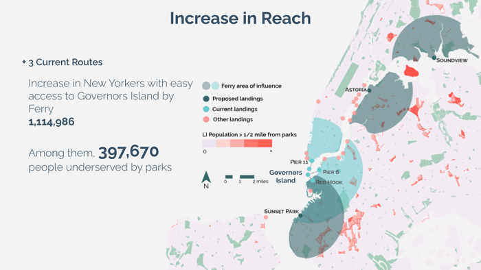
Our vision is to situate Governors Island as a reference for other cities and neighborhoods of resilience to climate change that can also provide positive experiences to all New Yorkers and their families. We believe Governors Island can play a role in advancing park equity citywide, with a particular focus on nearby communities like Red Hook and Sunset Park, and more distant neighborhoods like Astoria in Queens and Soundview in the Bronx.
There have been long-standing inequities in park access for New York communities. During the pandemic, we saw how essential park access was for New Yorkers. The Trust for Public Land estimates that during the pandemic 1.1 million New Yorkers did not live within a 10-minute walk of a park. Governors island is also a huge asset beyond the need to provide open space that is currently restricted due to transit burdens and accessibility difficulties. As such this project recommends the expansion of direct routes to governors island on the NYC ferry into Sunset Park, Astoria, and Soundview, which would expand access to over 1 million new yorkers, 400,000 of which live in areas underserved by parks.


Our resilience recommendations can be broken into three categories, buildings, waterfront, and managed retreat. These strategies take on a phased approach which deals with more acute short-term risks due to coastal storms and flooding, as well as chronic risks due to sea-level rise.
Buildings
In order to maintain the history and beauty of the northern district, while providing opportunities for adaptive reuse as part of the center for climate resilience, the first recommendation identifies buildings that are at immediate risk of flooding. These risks are assessed using FEMAs 2015 flood maps that identify a 1% flood risk and 0.2% flood risk zone. Based on this analysis, we identified 4 categories of buildings: Category 1 - Buildings in a 1% flood zone with no raised ground floor; Category 2 - Buildings in the 1% flood zone with a raised ground floor offering some level of protection for usable space; Category 3 - Buildings not under immediate risk (these buildings might be in the 0.2% flood zone but will be protected through the waterfront recommendation), Category 4 - Intrusive or Non-contributing buildings in the floodplain that do not merit protection or where it is not feasible in a reasonable way to protect the building(s). Based on these identifications, we recommend the raising of mechanical equipment for category 1 and category 2 buildings. We also recommend wet floodproofing the ground floor for category 1 buildings and the basement for category 2 buildings. For category 3 buildings, we recommend no immediate action as they will be protected by the waterfront strategy. Furthermore, we recommend disassembling category 4 buildings and reusing their parts creatively elsewhere on the island.
Waterfront
The waterfront strategy identifies areas along the waterfront where it would be feasible to fortify and raise the existing sea wall and waterfront esplanade that would have the most impact on protecting historic buildings on the island. By providing fortification, the interventions also provide opportunities for beautiful public space and amenities. Our recommendation is to fortify the East and West waterfronts while utilizing existing typologies of the island along the north that protects inland walls and elevation. This fortification would be accompanied by rain gardens to prevent the pooling of stormwater from the raised fortifications.
Managed Retreat
The last strategy is to involve the area of the Northern District left exposed to sea-level rise and storm surge. This area has 4 buildings, three of which are non-historic buildings and the last of which is a historic building, the first you see when arriving at the island from Soissons Landing. Our recommendation is to deconstruct the 3 non-historic buildings as sea-level rise and storm surge begin to threaten the usability of those buildings while abandoning and converting the historic building into a climate change landmark. This conversion would coincide with the ripping up of pavement along with this subsection of the island and constructing that land into wetlands that will help to bring nature and biodiversity back to Governors Island. This wetland would have a raised path, creating a part of the island in which visitors can experience firsthand some of the effects of climate change and sea-level rise, seeing directly the impact on the historic building which was once fully protected on the island.
Spring 2021
Retail Apocalypse: Strategies for Local Communities
Two reasons are often given for the retail apocalypse: the overextension of suburban malls and the rise of e-commerce. But the two are one in the same. The mall was a simulation of a vibrant public realm where none actually existed, and e-commerce arose to fill that void. Similarly, Hudson Yards is a simulation of urban space that castles away from the surrounding city. It crashes into Hell’s Kitchen South, a streetscape that the Lincoln Tunnel fractured and evicted of public life long ago. In both of these neighborhoods today, storefront vacancies are epidemic.
This studio seeks to provide its client, the Hudson Yards Hell’s Kitchen Alliance, with a path to revive retail in the district by restoring the public realm.
Students: Derek Brennan, Jianwen Du, Eryn Michelle Halvey, Hanbo Lei, Danqing Ma, Sarah Ann Mawdsley, Brady Meixell, Yixuan Ouyang, Eve Deena Passman, Sebastian Salas, Tiffany Vien, Yue Wei


We propose three possible uses for current vacancies. Community Living Rooms would provide indoor community public spaces; the Community Affordable Food Expo would provide low-cost food and act as a social hub, and a Homeless Services Center would address a vital neighborhood need.
To make our three proposed Civic Storefront ideas into reality, the key is to forge partnerships with existing organizations. We believe the BID itself would be the best fit to run Community Living Rooms. Landlords would be asked to provide their vacant storefronts short-term and rent-free until they find another tenant. The BID would provide minimal funding for low-cost furniture and play elements, run programming, and find volunteers to help with set-up and tear-down. Our CAFE concept could either be a partnership with an existing food waste app, a new nonprofit, or the CAFE could be housed in the Agora concept we outlined earlier. A potential way that the space could cover its rent would be through a $1 surcharge on all purchases. Our homeless services proposal would look to partner with an existing homeless services provider in the area such as Urban Pathways or Bowery Residents Committee. We propose the BID could offer to hold an annual fundraising event for the new space or foster connections with local companies that might be willing to provide donations.
Recreational Open Streets on 33rd, 37th, 38th, and 39th streets would be exclusive to pedestrians, but flexible to allow reduced speed traffic as needed during peak commuting hours and for emergency access. On nights and weekends they would feature community programming and events.
A shared street approach on 10th Avenue would create new and inviting public spaces on a relatively inactive corridor by incentivizing more ground floor retail
The transformation of 9th Ave as an auto-dominated transit corridor to a pedestrian centric shared street will make the street safer and improve pedestrian flow.
The current retail model is a traditional store with 1 tenant getting all the profits for the next 20 years. One flagship tenant is the most important part to build a retail atmosphere. Different from the current model, our proposal is aimed to set an “Agora” of entrepreneurship, culture, and local commerce to build stronger and more inclusive communities in Hell’s Kitchen Hudson Yards. This model provides on-demand and flexible leasing to accommodate over 1,000 tenants that create a more diverse and vibrant retail space.
In order to accomplish our main mission to heal the fractured urban landscape, re-integrate commerce with the everyday, and create a vibrant, flexible and dynamic retail environment for the future. We want to introduce a flexible floor plate that allows multiple programs to change over time while connecting retail with the public realm.
Our proposal aims to use omnichannel strategies that blend the physical and digital experience. First, we aim to provide an integrated online platform. We can show our rent spaces in existing platforms and in the new HYHK online platform. Flexible leases and pricing is based on business format and length of contract (hours, days, months, years.) Second, this new version of retail can also blend online and offline shopping. People can buy with their mobile phone and products are shipped home. It introduces a novel experience in a small scale format with a small store with samples and no inventory. Third, it utilizes social media interaction. By using popular social media, like facebook, we can build our own user community that can help advertising and promotions, give instant feedback and communication, and provide assistance to small businesses.
Spring 2021
Feeding New York City: Equitable Food Systems & Food Resiliency
The food system has never been primarily focused on making sure people are fed nutritious meals. Some obstacles to greater food access for historically marginalized communities are the result of an overreliance on the market to solve problems that in many ways the market itself creates. As with every disaster before, COVID-19 has impacted many of these same communities the hardest. It has made it clear the food system needs to be overhauled, and that includes, but not limited to, reimagining the built environment. In New York City, the South Bronx is an area where the inequities of the food system are most clearly manifested. Even though Hunt’s Point Cooperative Market, the City’s largest food distribution facility, is located in the South Bronx, the fact that the area continues to have the worst food insecurity in the city is nothing short of food apartheid.
This studio aimed to design a conceptual framework for a food hub located in the South Bronx of New York City. A neighborhood food hub is a community-led institution that provides missing infrastructure, such as a kitchen, storage, and community space, to support food security in communities. It works by actively linking regional producers with food entrepreneurs and emergency service providers, such as food pantries and food banks. By utilizing a hub and spoke model, the food hub can serve a variety of different community needs.
The client for this studio was the City Council’s Land Use Committee.
Students: Tamim Abedin, Rousol Aribi, Shreya Arora, Boyang Dan, Jackson Pierce Fordham, Danielle M Roberts, Al Tariq Ibn Shabazz, Yining Shen, Erik Ryan Strand, Sherry Aine Chuang Te, Yifei Zhou


Food Apartheid in the South Bronx
The South Bronx is in close proximity to one of the largest food distributors in the state. Hunts Point is responsible for 60% of the city’s produce, yet 17% of South Bronx residents are food insecure.
Food Access in the South Bronx
The South Bronx has the highest food insecure population in New York City. The population is majority Black and Latino and has high levels of health concerns, poverty levels.
Site Strategy 1
The Concord Ave site is a near-perfect site for a Neighborhood Food Hub, both from a spatial as well as a social justice perspective. It is well-connected to the subway and bus systems, as well as to the road infrastructure to support regular truck use. It sits on the edge of the highest-need population by our MCDA in the South Bronx, with a dense population of mostly low-income, Black and Brown, high food insecurity residents.
Site Strategy 2
The site could benefit from adding food hub components in the vacant spaces surrounding the NYCHA buildings, which would arguably be more feasible as they serve as complements to the existing site functions, such as low-income residential areas, schools, and churches nearby.
Equity Framework
The equity framework establishes four major touchpoints of action on how the Food Hub aims to work as a third place. The components shall promote food democracy and empower all members of the community to shape their food systems. The organization housing community representatives as stakeholders versus being shareholders, allows for a representation of the needs of the diverse community, to power effective decision making.
Food Hub Mission
Our framework aims to serve as a transferable and modifiable framework for food hubs to implement these explicit goals of equitably increasing food access in communities, resting on the foundation of communication, collaboration, and empathy.
Spring 2021
Caribbean Reconnections in Culebra
Building on the work of previous studios and courses on Culebra and Vieques and the relationships developed over time with the local communities, the “Caribbean Reconnections in Culebra: Plan to Implementation” studio uses the interdisciplinary approach of the “joint studio” format to develop designs and planning strategies in response to issues of food, energy, and water sovereignty, waste disposal, resiliency, disaster management, education, job creation, and public space, among others. A particular focus is on water as nexus for the above issues. The studio also focuses on implementation considerations for both this current studio’s plans as well as projects developed previously, in close collaboration with our principal client, the Mujeres de Islas in Culebra.
Students: Willy Pan Cao, Teonna Nichol Cooksey, Katherin Sibel, Zhaoxiang Yun, Hanyin Zhang

“Oasis strategically furthers community resilience and challenges land boundaries in Culebra primarily for the residents of Villa Muñeco … the proposal focuses on water as a connecting feature, while fostering a sense of community through living and gardening.”
“While lack of water defines the island of Culebra’s precarious condition, it is the land that presents a way of linking past and future narratives and upholds the ecological and civic life of the Puerto Rican island. This project for a food waste upcycling plant and adjoining plant nursery is both an endeavor to revitalize the island’s soil and a reclaim violated land, where traces of unexploded ordnance and soil contamination dot an island from decades of U.S. Naval occupation.”

Sargatopía: Sargassum-Based Restoration Economy
Sargassum is a pernicious genus of seaweed that is characterized by odorous methane-releasing blo…
Ecological Research Center for Social, Infrastructural, and Education Resilience
The Ecological Research Center proposes a strategy for the reoccupation of an abandoned factory b…
Sovereign Living: Housing as Adaptive Process within a Community Land Trust
Culebra faces unique challenges in affordable housing due to the tourism-fueled Airbnb market, hi…
Spring 2021
Cities in Crisis: Planning in Comparative Perspectives
This seminar focuses on the role of planning in cities facing crises such as hurricanes, earthquakes, explosions, economic crisis, violence of war, racism, and displacements. The course explores the use of the controversial term “crisis” and critiques of the term. Students discuss what it means to be a “city in crisis” or declare an event as a crisis, examining what the labelling of a moment, an event, or geography as crisis reveal about power, policy, the economy, profit, structural forces, and histories of injustice and dispossession. Thinking comparatively across cities in the global north and south, students review case studies both recent and historical, considering what happened in the event, what planning interventions followed, and what the implications—or repercussions—of those interventions may be. Case studies include earthquakes in Santiago (Chile), Port-au-Prince (Haiti), Mexico City (Mexico), hurricanes in New Orleans and New York (USA) and San Juan (Puerto Rico); explosions and attacks in Fukushima (Japan), Beirut (Lebanon), and New York (USA); economic crises Buenos Aires (Argentina), Athens (Greece), and Harare (Zimbabwe); racial violence in Sanford, Florida (USA), Paris (France), and Bogota (Colombia).


This research on the 2020 Beirut explosion asks: If corruption led to economic and social crisis and the blast, how is sidelining of the state affecting long-term state viability?
This research comprises a literature review of both humanitarian organization-oriented and social science-oriented sources. In drawing from both NGO and local analyses, I hope to locate practices that could foster a less colonial approach to disaster response. I also place Cuba’s disaster response system in conversation with these emergent practices of mutual aid: in many ways, what theorists learned in the aftermath of the Haiti disaster was already implemented, in a top-down manner, by the Cuban government, which is highly successful at limiting damage and human casualties from disasters (Castellanos Abella, 2008).
In efforts to address environmental inequities, cities in Latin America have tried to close and recuperate landfills. Three case studies show that the environmental injustice does not stop with these closures as the sites shift into nodes of new urban crises.
This research, titled “Aftermaths of the Tunisian Revolution: Decentralization and the Shift to New Planning Practices” asks: Have decentralization policies and emphasis on participation truly influenced planning policy and project implementation since the Revolution?
This research on crisis-driven urban transformation asks: Why do people relocate their houses again and again? What makes the coastal cities vulnerable to disasters, especially tsunamis?
Spring 2021
Urban Design For Planners
This course helps students acquire the principles that can inform urban design practice. It has three major pedagogical objectives. First, it helps students understand the contemporary city through a series of urban design tools. Second, it covers both historical and modern urban design principles. Finally, it includes all the scales in which urban designers operate, ranging from the fundamentals of social interaction in public space to environmental sustainability of a region.
Students: Hayes Buchanan, Claire E Douglas, H K Dunston, Lily Li, Jonathan Marty, Sarah Ann Mawdsley, David McNamara, Jason Scott Mencher, Nicholas Lincoln Perry, Erik Ryan Strand, Jiabao Sun, Tiffany Vien, Jiuyu Wang, Haoran Zhang


Spring 2021
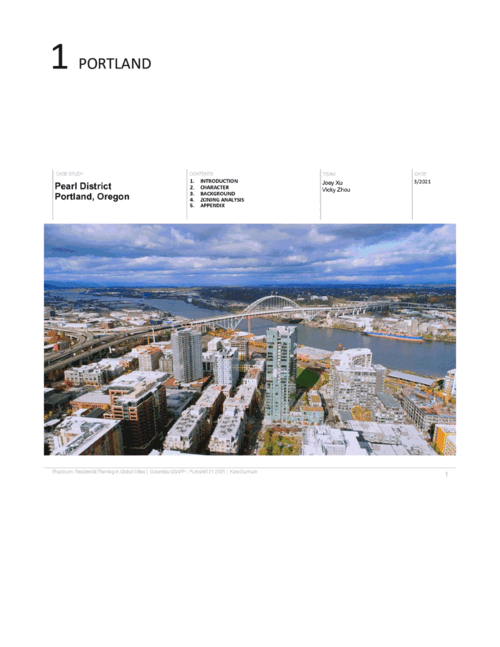
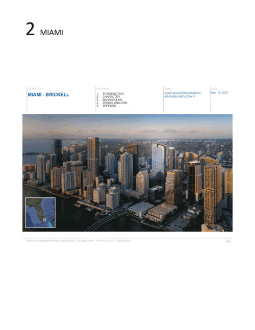
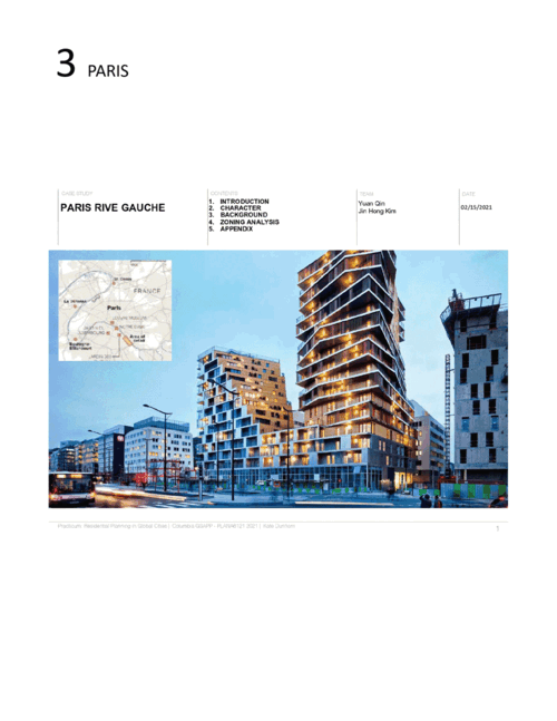
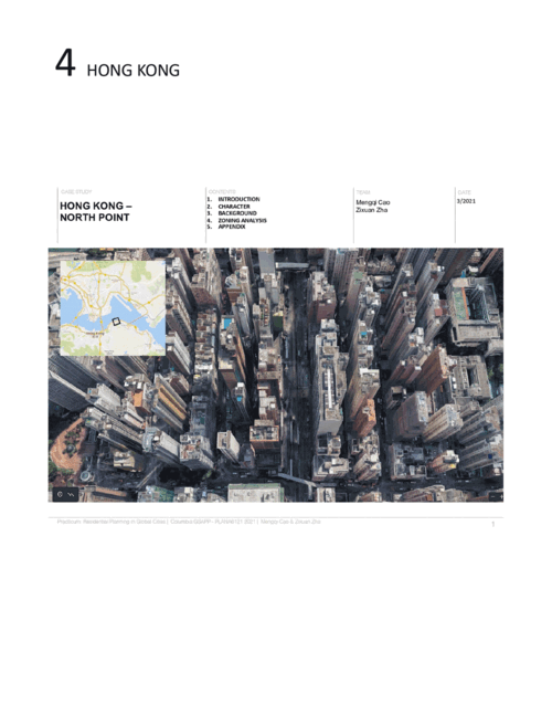
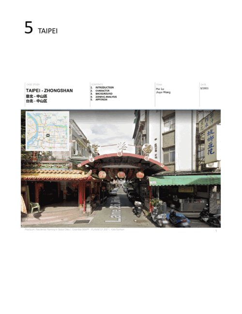
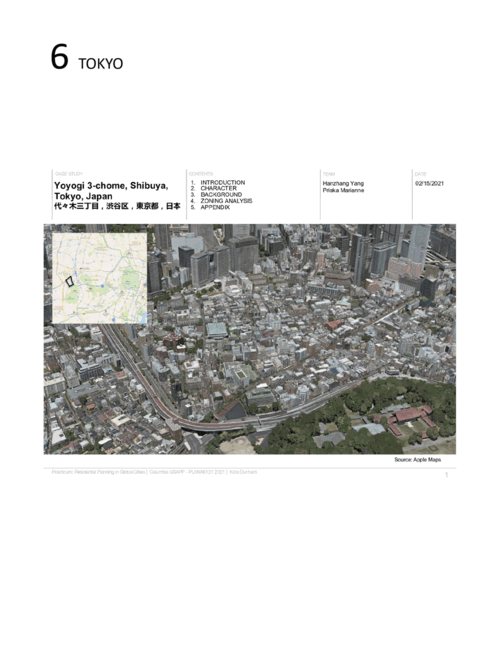
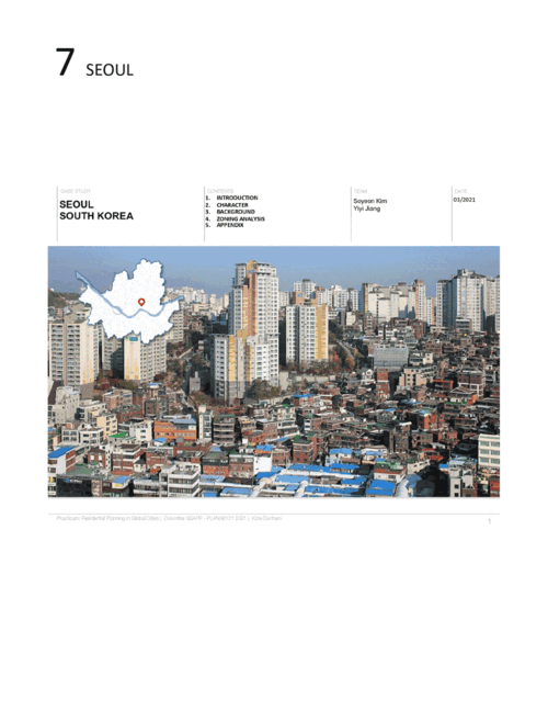
Practicum: Residential Planning in Global Cities
As the world’s urban population grows towards six and a half billion by 2050, cities all over the world are resorting to the mass-production of residential super-blocks to address new urban housing demands. But is this model appropriate for all cities, regardless of their environmental, social, political and economic differences? This seminar provides students with a hands-on opportunity to understand how planning code regulations - specifically residential codes - can shape the design and functioning of future neighborhoods in our rapidly urbanizing age. In this course students explore case studies from around the world, learn about different planning models and have a chance to develop their own ideas of how to use zoning as a tool to better address challenges facing cities today. This seminar offers a multi-disciplinary approach to thinking about zoning and gives students from different related fields, such as architecture, urban design, planning and real estate, an opportunity to work collaboratively and holistically as they think about the complex planning challenges ahead in our urbanizing world.
Students: Mengqi Cao, Mariana Hinojosa, Yiyi Jiang, Jin Hong Kim, Soyeon Kim, Hui Lu, Priska Marianne, Juan Moreno, Yuan Qin, Jiuyu Wang, Joey Xu, Hanzhang Yang, Zixuan Zha, Vicky Zhou
Fall 2020
Intro to Urban Data and Informatics
Data analytics and data-driven processes are used to make urban planning decisions and improve related city service operations. This course provides an introduction to the technical, theoretical, and practice-based dimensions of urban analytics. It is centered around data acquisition, numerical analysis, spatialization, visualization, interaction, and civic technologies. Students learn concepts, software tools, and analytical techniques to extract meaningful information from various data sources and analytical practices. The course engages the role of technologies and computational methods in the planning process. The main objective is to familiarize students with modern computational techniques and demonstrate how their application to real-world problems alongside the planning perspectives.
Students: Tamim Abedin, Rousol Aribi, Hayes Buchanan, Tihana Bulut, Mengqi Cao, Willy Pan Cao, Jianwen Du, Jackson Pierce Fordham, Lanier Hagerty, Sori Han, Mariana Hinojosa, Geon Woo Lee, Hanbo Lei, Moses Narayan Levich, Lily Li, Lisa Li, Shih Yu Liu, Danqing Ma, Moheng Ma, Priska Marianne, Juan Sebastian Moreno, Yuan Qin, Mauricio Enrique Rada Orellana, Danielle M Roberts, Zeineb Sellami, Yuanyuan Shen, Erik Ryan Strand, Jiabao Sun, Sherry Aine Chuang Te, Xifan Wang, Jade Tara Watkins, Shen Xin, Hanzhang Yang, Angel Yin, Zixuan Zha, Hanyin Zhang, Yifei Zhou
“As an exploration of urban informatics, the Females on Wheels project examined female Citi Bike ridership in New York City Summer 2020.”


“New York City’s taxi industry is in crisis due to the cost of medallions, ridership during the pandemic and competition with rideshare services such as Uber. Using the Manhattan Neighborhood Tabulation Areas (NTAs) as the units of study, we calculated the percental change of yellow taxi trips between 2019 and 2020 to identify which NTAs have increased, decreased, or maintained previous ridership behavior.”
“This project compared NYC 311 data during significant dates of the COVID-19 pandemic (As of October 2020) to the 311 data on those same dates in 2019.”
One interesting finding in comparing the Chicago trip data of April 2020 and September 2020, surprisingly, resides in a huge difference in time-travel pattern — both in terms of a week and in regard to a day. The result shows that in April, Chicago residents tended to travel during weekday nights, while in the weekends, they would not travel at any time. Conversely, in September, trips in weekdays were taken almost evenly in terms of morning, afternoon and night, while in weekends, the number of trip suddenly become very large in most Chicago communities.
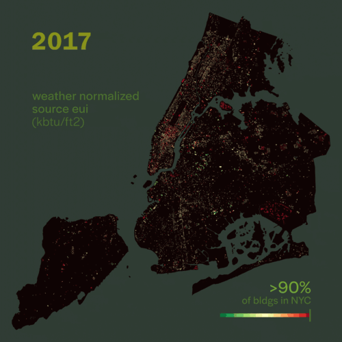
Energy efficiency in buildings plays an outsized role in the fight against climate change. In New York City, buildings account for 66% of the city’s greenhouse gas emissions. In 2009, New York City introduced a benchmarking law that requires owners of large buildings to measure and report their annual energy consumptions. This dataset allows us to formulate and test our research question, “What are the trends in energy efficiency in buildings in NYC.” We explored this question in three perspectives: building scale, neighborhood scale, and temporal scale. This research has shown that the size of the building correlates with electricity consumption and GHG emissions. Yet, energy use intensity (EUI) is irrelevant to size, age, and density of a building. Thus, old and large buildings can be highly energy efficient contrary to common misconception. Also, identifying spatial patterns of energy consumption at different scales can have enormous potential to develop targeted energy strategies per neighborhood.
As climate change drives global average temperatures upwards, variability in winter weather patterns is also expected to increase (Conlon et al., 2011). There is a widely accepted methodology for creating a neighborhood-level heat vulnerability index, and several such indices have been created for New York City. However, there is much less information available on neighborhood-level cold vulnerability. To account for the susceptibility of different population groups, we used the concept of social vulnerability developed by Cutter et al (2003). We combined several social indicators, case datasets, and environmental factors in our analysis, including an interpolated map of weather station data from 82 stations in the New York Metro area, to create the cold vulnerability index for Brooklyn. Some neighborhoods exhibited high vulnerability to both heat and cold, as measured by our cold index and the 2010 NYC Heat Vulnerability Index. These neighborhoods most notably include parts of central Brooklyn like Midwood and Flatbush. The availability and reliability of data was a major limitation on the scope and applicability of our research. Uncertainty is also added into our cold index model through the use of interpolation. Further study could focus on the relative weights of different factors for environmental and social risk. With more thorough weather station observation data, this model could also be expanded to include the rest of New York City. Finally, similar study research could be applied to determining vulnerability in the context of COVID-19.
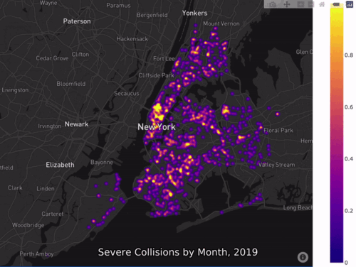
Severe Collisions in NYC
This urban informatics project explores the correlation between severe traffic collisions and the…
Nowhere to Play
This research investigates playground closures and alternative open space for children in NYC. Ou…
Spring 2021
Exploring Urban Data with Machine Learning
This course engages the role of technologies and quantitative methods in the planning process. The main objective is to familiarize students with modern machine learning techniques and demonstrate their application to urban data and real-world problems alongside the planning perspectives. Students learn to apply the skills and techniques necessary to understand the motivation behind different machine learning methods and their applicability in a given practical context; implement and develop a methodological framework; model algorithms; interpret and evaluate results appropriately; deliver insights concerning urban planning perspectives and real-world problems.
Students: Regina Joy Duque Alcazar, Tihana Bulut, Willy Pan Cao, Jianwen Du, Yuehui Du, Jackson Pierce Fordham, Lanier Hagerty, Sori Han, Jin Hong Kim, Hanbo Lei, Chao Li, Chengliang Li, Lily Li, Qi David Lin, Moheng Ma, Priska Marianne, Yixuan Ouyang, Mauricio Enrique Rada Orellana, Helena H Rong, Erik Ryan Strand, Jiabao Sun, Sherry Aine Chuang Te, Xifan Wang, Hanyin Zhang, Haoran Zhang
Fall 2020
Environmental Data Analysis
Planners are increasingly in need of analyzing environmental data to curb and anticipate the effects that come with climate change for adaptation and mitigation. This course introduces methods of environmental data analysis across varying geographic scales and underlying planning issues in the context of climate change. The structure of the course is defined through four modules (Global, National, Regional, and City) to introduce students to the variety of environmental data and analyses for different geographies. Students master different skills including spatial suitability, data management, scenario development, and machine learning to answer scale-specific research questions. The course uses analytics that propel planners into the world of big data and help model the complexities of climate change-related environmental processes.
Students: Myles Benjamin Agudelo, Regina Joy Duque Alcazar, Justin Michael Barton, Willy Pan Cao, Elaine Mingsum Hsieh, Jin Hong Kim, Geon Woo Lee, Qi David Lin, Shih Yu Liu, Hui Lu, Priska Marianne, Yixuan Ouyang, Mauricio Enrique Rada Orellana, Zeineb Sellami, Katherin Sibel, Sherry Aine Chuang Te, Xifan Wang, Shen Xin

Fall 2020
Geographic Information Systems
This course introduces core concepts of GIS and GIScience, as well as technical skills crucial for working within urban environments. Students learn critical approaches to spatial analysis and visualization and embed these techniques within larger design workflows. By creating and analyzing diverse types of spatial data—and layering those within complex maps—students are challenged to build arguments and construct geospatial narratives.
Students: Tamim Abedin, Rousol Aribi, Shreya Arora, Derek Brennan, Willy Cao, Leila Collins, Teonna Cooksey, Boyang Dan, Jianwen Du, Jackson Fordham, Eryn Halvey, Sori Han, Nile Johnson, Hanbo Lei, Moses Levich, Danqing Ma, Moheng Ma, Jonathan Marty, Sarah Mawdsley, David McNamara, Brady Meixell, Yixuan Ouyang, Eve Passman, Mauricio Rada Orellana, Danielle Roberts, Sebastian Salas, Al Tariq Shabazz, Yining Shen, Yuanyuan Shen, Katherin Sibel, Erik Strand, Jiabao Sun, Sherry Aine Te, Tiffany Vien, Yue Wei, Shen Xin, Zhaoxiang Yun, Hanyin Zhang, Yifei Zhou, Stefan Norgaard, Ranjani Srinivasan


Spring 2021
Advanced Spatial Analysis
This advanced seminar examines and develops techniques of spatial analysis and representation specific to urban contexts. The course centers around key methodologies—including advanced spatial statistics, spatial decision support systems, feature recognition, and interpolation—interrogating their use and applicability to different contexts in research and practice. Through case studies, students learn several new methods, comparing distinct approaches to similar questions and considering the implications (ethical and otherwise) of spatial analysis and cartography.
Students: Tamim Abedin, Myles Benjamin Agudelo, Regina Joy Duque Alcazar, Sebastian Henrik Mauritz Andersson, Mengqi Cao, Willy Pan Cao, Lanier Hagerty, Mariana Hinojosa, Elaine Mingsum Hsieh, Jean Kim, Soyeon Kim, Spenser Anne Krut, Moses Narayan Levich, Shih Yu Liu, Hui Lu, Juan Sebastian Moreno, Mauricio Enrique Rada Orellana, Helena H Rong, Sebastian Salas, Zeineb Sellami, Ranjani Srinivasan, Jiuyu Wang, Xifan Wang, Hanzhang Yang, Angel Yin
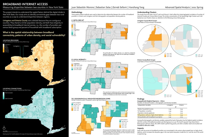
This project intends to understand the spatial factors behind the digital divide in New York State. Our study aims to identify connectivity gaps between two rural counties to understand disparities between regions.
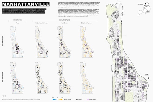
Manhattanville
How has the planning (2003), development (2009), and construction (2018) of the new campus change…
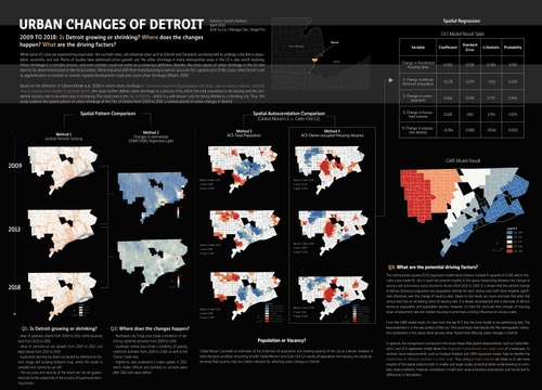
Urban Changes of Detroit
From 2009 to 2018: Is Detroit growing or shrinking? Where do the changes happen? What are the dri…
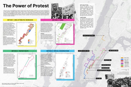
The Power of Protest
In NYC, the weeks following the death of George Floyd in May 2020, masses of people took to the s…
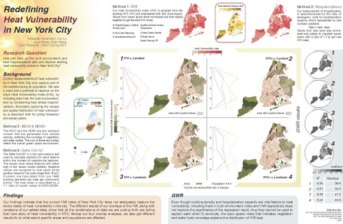
Redefining Heat Vulnerability in New York City
How can data on the built environment and heat hospitalizations alter and improve existing heat v…
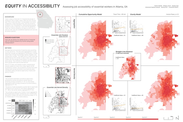
How can we asses the spatial access of essential jobs for Atlanta residents by income using public transportation?
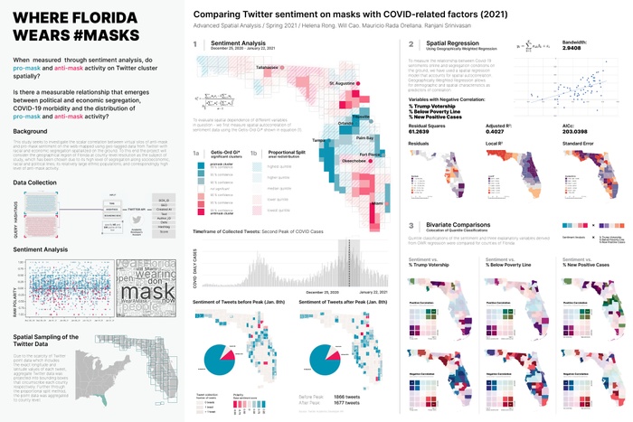
When measured through sentiment analysis, do pro-mask and anti-mask activity on Twitter cluster spatially? Is there a measurable relationship that emerges between political and economic segregation, COVID-19 morbidity, and the distribution of pro-mask and anti-mask activity?
Fall 2020
Resilient Urban Systems
In the practicum Resilience, Reparations and the Green New Deal: Climate Justice in Our Own Backyard, students learned about the impacts of environmental racism and climate change in the neighborhoods surrounding Columbia University. They also learned from Dr. Sharon Egretta Sutton’s When Ivory Towers Were Black about Columbia GSAPP’s early experiments with community-driven design and planning and engaged in a critical and proactive discourse on how students and faculty of GSAPP today can better promote climate justice in our backyard. Students developed oral and visual communication tools necessary to promote this work.
Students: Rousol Aribi, Chase Gordon Ballas, Hayes Buchanan, Tihana Bulut, Teonna Nichol Cooksey, H K Dunston, Colin Malik Hancock, Sanjukta Kashyap Hazarika, Nile Meridian Johnson, Victor Yuan-Ting Lo, David McNamara, Juan Sebastian Moreno, Thanawat Phituksithkasem, Zeineb Sellami, Shoshana Alexa Sheinfeld, Erik Ryan Strand, Jordan Welnetz, Vicky Zhou


Urban Planning Theses
Urban Planning Theses
MYLES AGUDELO
Luring Investment Through Higher Taxes: Evaluating the Impact of New York City Business Improvement Districts on Property Development
Advisor: Moira O'Neill
Business improvement districts (BID) are a widely used tool intended to address quality of life concerns and promote economic development. While BIDs have been shown to provide a variety of positive impacts to their districts, it is less clear whether these impacts translate into increased levels of commercial property development within the district. There is also a question of whether any observed increases in development are a result of existing economic resources that have been shifted from surrounding districts. This thesis attempts to quantify the impact of New York City’s BIDs on commercial property development both within BIDs and their surrounding neighborhoods. To evaluate a BIDs role as an economic development tool, this thesis uses a difference-in-differences approach to compare the number of construction permits both in and around three Manhattan BIDs before and after the BIDs were established. Results show that BIDs do not play a significant role in increasing levels of commercial property development within their districts and neighborhoods surrounding BIDs do not experience a decline in commercial property development after a nearby BID is established. These results call into question a BIDs role as a major economic development tool, especially as the number of BIDs in New York City continues to grow.

Illustration by Hayes Buchanan.
C. HAYES BUCHANAN
Performative Democracy: Participatory Planning, Co-optation and the Laundering of State Power in the South Bronx
Advisor: Hiba Bou Akar
This research evaluates the role of participatory planning mechanisms such as Community Boards (CBs) and public hearings through two case studies involving environmental justice advocacy in the South Bronx. By tracing the theoretical and political underpinnings of the Postreform era of planning I contend that the results of the movement to democratize the planning process as encoded in the 1975 and 1989 charter reforms were severely flawed because it did not meaningfully devolve power to citizens—an observation often overlooked by contemporary academics. In the intervening years, the agency afforded to communities by these processes has developed unevenly: while some wealthy neighborhoods have wielded their CB to effectively achieve their goals, others like those in the South Bronx have found their priorities repeatedly ignored, overridden, or watered down. Through a thorough examination of the economic development deal which resulted in FreshDirect moving their headquarters to a site in Port Morris and the Sheridan Expressway redesign, I develop a theory of co-optation that instrumentalizes participation to launder state power to private interests, signaled by a retreat by activists from the official venues of the planning process in favor of ad-hoc advocacy groups.

Illustration by Tihana Bulut.
TIHANA BULUT
Resilience Planning as a Means for Disaster Risk Reduction, Recovery, and Preparedness in the Rockaways: Insights from Hurricane Sandy & COVID-19
Advisor: Leah Meisterlin
Resilience planning has emerged as a recently popularized phenomenon in the field of urban planning, having the potential to reduce urban disaster risk while also enhancing disaster recovery and preparedness. Current urban planning literature fails to consider resilience planning as a continuous process that integrates conditions of the pre- and post-disaster landscape. Planners practice resilience through phases, organizing after a disaster to plan and rebuild, largely ignoring the time before the disaster despite its potential for ensuring long-term community resilience. In a context where disasters are becoming more frequent, this time before needs to be considered when planning for resilience. This study attempts to reframe resilience in the field of urban planning by analyzing how resilience is practiced on the ground at the community level.
This study argues that resilience planning needs to consider dynamics across temporal space by studying the time in between disasters. In New York City, this refers to the near-decade separating Hurricane Sandy and COVID-19. This framework is applied and informed by a case study analysis in Rockaway, New York City, a community that has been disproportionately impacted by both Hurricane Sandy and COVID-19. The methods in this study include a series of qualitative semi-structured interviews with city agency representatives and community organizers. Findings conclude that in Rockaway, the practice and implementation of resilience planning within the last decade has contributed to issues of distrust, trauma, and burnout, negatively impacting COVID-19 recovery thus far. These findings emphasize the need for resilience to be practiced continuously as the recontextualization of everyday risk can help reduce community distrust, trauma, and burnout that have emerged as a result of the resilience planning cycle.

Photo by Riley Burchell.
RILEY BURCHELL
Between Essentialisms: An Exploration of Non-binary Racial Identity and Place-making
Advisor: Leah Meisterlin
Over the past forty years, the practice of transracial adoption has become an increasingly pervasive occurrence, specifically as it relates to the extraction of infants and children from East Asian countries to the United States. While this increase in prevalence has been noted and corroborated by state and country data as well as academic research conducted on the topic, little has been pursued that establishes its significance in terms of individual, community and place-based identity development. This research aims to evaluate the effect of place on East Asian transracial adoptee identity development in these multiple contexts. Specifically, it focuses on the experience of East Asian transracial adoptees in New York City and the ways in which members of this community employ spatial, social, and cultural place-making practices in their efforts to create landscapes of belonging reflective of their unique identities. Informed by a review of pertinent literature across the disciplines of sociology, psychology, geography and urban planning, survey responses from East Asian transracial adoptees, and interviews with place-making and adoptee community development professionals and East Asian transracial adoptees in the New York City area, this thesis proposes a new conception of place-making that addresses the liminal experience of the East Asian transracial adoptee identity and carries implications for place-making for other non-binary identities.
MENGQI CAO
How NGO Benefits their Local Communities:
a Stakeholder Analysis and Evaluation of Dayu’s Role in the Regeneration Process of Old Residential Compound in Shanghai
Advisor: Weiping Wu
Shifting from a phase of rapid growth in urbanization into a moderate-paced stage, China has faced many complicated problems during the urban regeneration period. To deal with complex urban problems, urban regeneration often requires integrated and coordinated strategies involving a wide range of stakeholders. Hence, a deeper understanding of the stakeholders is an essential step towards sustainable urban regeneration. Besides, many NGOs have emerged to try to provide a smooth communication platform for all parties. Therefore, this thesis would like to explore the interaction between various stakeholders and the role NGO plays in the regeneration process of old residential compounds in Shanghai through case studies. It will include a case study of Hongxian Residential Compound Regeneration Project and rely on interviews and observations to help understand stakeholders in a more in-depth way. The method of stakeholder analysis will be employed to identify, prioritize, analyze the stakeholders and their roles.
The result shows that the government occupies an absolute dominant position in the power structure, while NGO has also been empowered to take a lead. Local residents and other participants have few say during the regeneration process. Meanwhile, NGO would serve as both of a key mediator, and an organizer and provider of community cultural services in the different stages. Therefore, the author calls for the policy support for NGO’s involvement, the empowerment of different stakeholders and the encouragement of public participations in the future.
Illustration by Camille Esquivel.
CAMILLE JAYNE ESQUIVEL
Responsibly Powering the Philippine Islands with Geothermal Energy
Advisor: Hiba Bou Akar
The research conducted in this thesis interrogates the impact of geothermal energy infrastructure in the Philippines, and highlights the risks associated with any future development. Through a deep dive historic literature and multimedia review, the study lays the foundation of the worsening energy crisis in the Philippines, and outline where aid has been received to fund resiliency and environmental conservation projects in this disaster-prone country. Through the case study of one of the largest geothermal energy plants in the world, the Tiwi Geothermal Complex in Albay, Bicol, policies, laws, and social movements are reviewed to better understand how the presence of the state and NGOs has shaped life and development in the region. By understanding the drivers of development and decision-making in the region, the potential of geothermal energy infrastructure to be a catalyst for resilient development that adequately improves the conditions and quality of life for local people, centering the struggles of indigenous peoples and subsistence farmers in defending their lands. The current scale of implementation and management of geothermal energy is challenged to re-prioritize the needs of people at the smallest administrative division, the ‘barangay.’
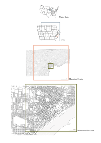
Illustration by Lanier Hagerty.
LANIER HAGERTY
Small Town, Global City: The Changing Landscape in Muscatine, Iowa from 2010 to 2020
Advisor: Leah Meisterlin
On February 15, 2012, Xi Jinping, then vice president of China, visited Muscatine, Iowa, a small town on the banks of the Mississippi River with a population just under 24,000. Though the visit lasted just one hour, it would shape the trajectory of Muscatine for the next decade. In the years that followed, Muscatine was the recipient of significant Chinese political, social and financial capital investment.
Muscatine’s story is a story of global exchange, diplomacy and strategic political partnerships, phenomena that shape some of the world’s biggest cities. This thesis seeks to understand the nuances of these power networks in Muscatine’s context and the tradeoffs for the community that have resulted from Xi Jinping’s visit in 2012. This research can be divided into two distinct lines of inquiry: (1) Where is Muscatine positioned in a network of county, state, national and international global capital flows? (2) What implications has the influx of foreign capital spurred by Xi’s visit had on the Muscatine community?
Results suggest that while Muscatine is a conduit through which Iowa and China have conducted their relationship, the small town has leveraged its position in a way that has ensured its benefit and protected against its exploitation. Muscatine’s role as a node in major networks of international trade, foreign direct investment and cultural diplomacy turns conventional frameworks of urban scalar dynamics inside out.
Illustration by Agnes Lee for the New York Times.
SANJUKTA HAZARIKA
On Reclaiming the Streets for the People’: Understanding Equity in Public Space Planning Strategies Through an Analysis of the Open Streets Program in New York City
Advisor: Hiba Bou Akar
Streets are a vital part of the public realm. They no longer simply exist for mobility but as a way to act out democracy. As New York City garnered global attention in becoming an epicenter of the COVID-19 pandemic, city officials looked to streets to provide outdoor respite from months of indoor isolation for New Yorkers. This came as a response to the ‘new normal’ that unfolded as a result of the pandemic; New Yorkers were spending time outdoors and taking to the streets for everyday activities while being able to safely follow social distancing protocols. Open Streets were a lifeline for the city’s recovery. The pandemic gave urban planners and policymakers an opportunity to rethink our streets for a more climate-resilient, less car-dependent future.
If these Open Streets bring social, economic, and environmental benefits, it is only fair that all New Yorkers have the same level of access to it. The approach will have to begin with justice. It would be the most reasonable to have Open Streets for those that need it the most—the neighborhoods hit the hardest by COVID-19, the ones with the least access to quality public open spaces, and the communities with the least mobility options. This thesis explores the meaning behind equity with regard to this program. However, the rise of community organizing surrounding the program has given rise to some of the city’s best Open Streets. Equity, with regard to this program, then calls for a more nuanced definition—it is about understanding and responding to the needs of each community.
The thesis looks into the genesis of the Open Streets program in New York City and analyzes its implementation. Through a case study analysis, it evaluates Open Streets in Williamsburg and Bedford-Stuyvesant in Brooklyn and Jackson Heights in Queens. In comparing how different communities across the city experience this program, this research aims to explore what has and hasn’t been successful, in considering a more robust, permanent model for the future.
Diagrams by Elaine Mingsum Hsieh.
ELAINE HSIEH
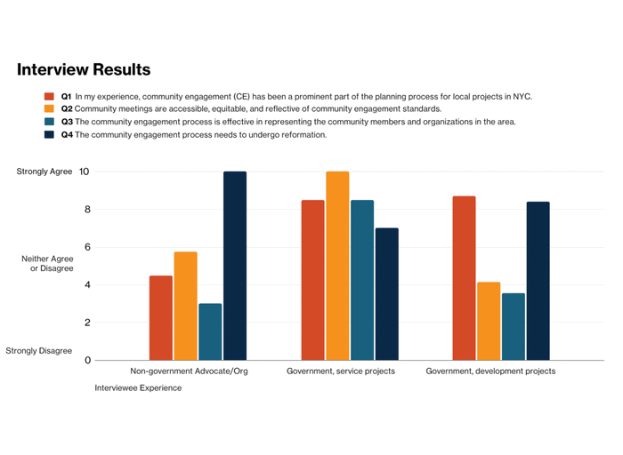
EnhanCE: Assessing the structure and efficacy of public-sector community engagement in New York City
Advisor: Leah Meisterlin
The purpose of this research is to contribute to a growing community of planners and active community members that believe in a future of fair, accessible, and empowering engagement. This research included questioning the role of planners and a stance on defining principles that should be recognized along with those currently recommended by the American Planning Association. The research is followed by a comparative analysis of the community engagement process of four case study projects in New York City, and is supported by additional in-depth discussion with planners and community organizations. Several implications were offered as a critique on the evaluation process of community engagement. First, despite having the necessary structures and democratic practices in place, the community engagement process of NYC is insufficient. Second, the time frame in which community engagement processes are open to the public limits the weight of community concerns in the decision-making process. Third, development projects often use tactics such as elongating processes which ultimately leads to community burnout and distrust in city governance.
GEON WOO LEE
Crossing Borders: Policy Transfer of Slum Upgrading Practices in Southeast Asia
Advisor: Weiping Wu
Throughout history, urban planners and international organizations have implemented urban slum upgrading projects across different time periods and geographies. This process, known as policy transfer, happens frequently in urban planning, yet planning is inherently about responding to the local context. Thus, understanding of policy transfer of planning practices, such as urban slum upgrading, is crucial. Using two recent slum upgrading projects (Vietnam Urban Upgrading Project and the Indonesia National Slum Upgrading Project) in Southeast Asia as case studies, this thesis seeks to understand how the World Bank adjusts the implementation of urban slum upgrading according to different local conditions. An evaluation matrix assessing the priorities of measurable objectives of the two projects with qualitative analysis of local conditions are performed to support the findings.
Photo by Caili Lisa Li.
CAILI LISA LI
A Framework for Sustainability Assessment of Urban Regeneration: The Case of Battery Park City
Advisor: Weiping Wu
Sustainability has gained growing importance in today’s urban development. In a highly urbanized context, to meet growing population needs, development or equity goals, additional social, economic or environmental benefits are created through urban regeneration projects within a city. This paper explores the concept of urban regeneration and sustainable regeneration, and its assessment methods. A sustainability assessment framework integrating three pillars ? social, environmental and economic aspects will be developed, and the assessment will be performed using the case of Battery Park City, an often-appraised waterfront urban regeneration project in New York City. The processes and results of the development are examined to provide insights on the critical factors and approach to deliver sustainable urban regeneration. In addition, this paper also seeks to contribute to sustainability assessment approaches. As sustainability assessments often focus on one aspect of the three pillars, the developed framework integrating all three pillars could be referenced for scholars that seeks to assess comprehensively.
The paper finds that Battery Park City has meaningfully achieved sustainability in terms of deriving social, economic and environmental benefits. Nevertheless, the assessment finds that the Battery Park City could have incorporated sustainability initiative in an earlier stage. It is revealed that tradeoffs between the three aspects and stakeholders are key characters in the result and development processes.
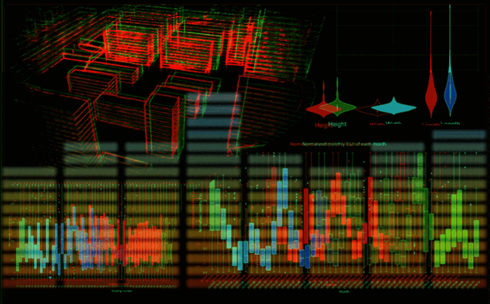
Photo by Qi David Lin.
QI DAVID LIN
Urban Building Energy Prediction at Community Scale: A Case Study Using Data-Driven Methods in Jianhu City, China
Advisor: Malo Hutson
Predictive models for urban building energy use have been the focus of much research in recent years, especially using data-driven techniques. However, these models still need to address recognized challenges, such as employing sufficient energy use data in spatial and temporal scales and accounting for interbuilding effects. In this regard, several typical data-driven predictive models for urban building energy use were proposed in this capstone to reduce the large data requirements and improve the prediction accuracy. Using a dataset of four years of electricity consumption by public buildings in Jianhu City, a county-level city in Jiangsu Province, China, and data on the corresponding building morphological parameters, this project compares the predictive performance of these models under different algorithms. The results suggest that a building network based on building morphological similarity can improve the overall performance of energy consumption prediction models for individual buildings in an urban context. This building network can also obtain relatively reliable energy consumption prediction results in the absence of historical energy consumption data of the target building. The project also reveals that the data-driven models can accurately predict total building consumption in a region when historical energy consumption of some buildings is not available. This study provides more comprehensive references and improved accuracy and robustness of urban building energy demand prediction, resulting in potential solutions reduced data requirements of urban energy models.
Photo by Shih Yu Liu.
SHIH YU LIU
Study of the effectiveness on public health-related planning efforts, with the respect to urban infrastructure in New York City and Singapore
Advisor: Leah Meisterlin
HUI LUI
The Collaboration Models of Practices of Aging in Place in Different Contexts
Advisor: Leah Meisterlin
With the aging of the population and the change in the way people choose to support their old age, it has become a popular way to enjoy aging life in a familiar environment. To study the practice mode of this senior care demand and the operating principle behind it, this study is devoted to studying the practice of Aging in Community in Shanghai and New York, and the effectiveness generated by the different cooperation modes formed among the government, the private sector and non-profit organizations. In this study, a comparative study was conducted in the way of document analysis and semi-structured interview to study and analyze the practice in the Shanghai embedded community-based senior care program and New York naturally occurring retirement community-supportive service program. Effectiveness was evaluated from three perspectives: innovation and its sustainability, comprehensiveness, and community integration. After analysis, it found that the Shanghai case mainly adopts the practice of the government-led model, which is a centralized model that can provide a set of continuous innovation, comprehensive but less integrated practice, while New York adopts shared responsibility model, which a more distributed model that provides a less sustainably innovative and comprehensive but more for the community and integration solution.
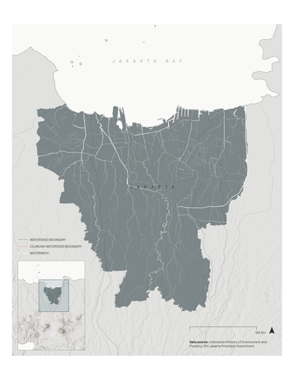
Illustration by Marainne Priska.
PRISKA MARIANNE
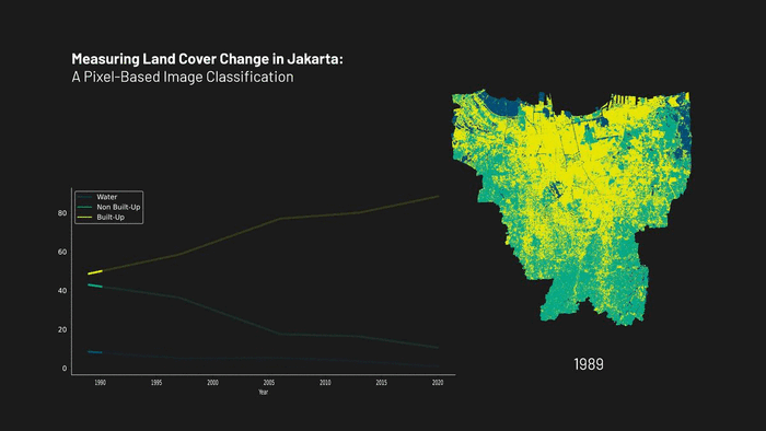
The Land-Water Nexus in a Sinking City: The Case of Jakarta
Advisor: Hiba Bou Akar
Coastal cities around the world are increasingly facing inundation hazards as urban expansion and population growth change hydrologic systems in the floodplains and compounding impacts of climate events accelerate and exacerbate these risks. The land and water dynamics in these shifting landscapes intersect with biophysical and sociopolitical dimensions that shape uneven flood vulnerability. This thesis explores the ways in which differential vulnerability to floods in Jakarta has been produced since the colonial rule and reproduced throughout major urban development phases in postcolonial Jakarta. Applying the framework of political ecology, this thesis investigates the three interconnected elements that are at play in the production of uneven flood risks: (i) the changes in land cover associated with rapid urbanization, (ii) the constant need to make room for water, and (iii) the inclination to turn to engineering solutions that are not context specific during moments of crisis. With the analysis of remotely-sensed data, this thesis explores a method to detect land cover change and their implications for modifying urban hydrology. Using two case studies of flood mitigation infrastructure, this thesis examines the ways Jakarta have navigated the tension between making room for water and maintaining space for people. It further introduces the concept of co-production in developing solutions to flood mitigation and climate adaptation actions, in the context of existing unequal power relations and the North-South divide. Finally, this thesis puts forward the importance of understanding and challenging the colonial legacy of fragmented water infrastructure and the ways they shape the production of uneven flood vulnerability and perpetuate socio-spatial segmentation in Jakarta.
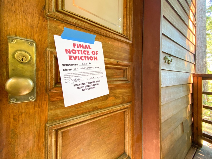
Photo of eviction notice by Bill Oxford.
JASON SCOTT MENCHER
Renter Protections against Eviction: Identifying and Analyzing Laws, Policies, and Procedures in Chicago, Houston, Los Angeles, and New York City
Advisor: Weiping Wu
For the roughly one third of Americans who rent their homes, eviction is an ever-present threat. Noting the negative effects of eviction including poor health, educational, employment, and social outcomes, in response, cities have enacted renter protections against the eviction of urban tenants. Such protections take the form of landlord-tenant laws, rent regulations (price controls), access to legal counsel, and specific legal procedures required to obtain an eviction judgment. Over the past year, in response to impacts of the Covid-19 Pandemic, local, state, and even the Federal government have taken unprecedented steps to further protect renters by issuing expansive, but temporary, eviction moratoriums. While existing literature examines causes and impacts of evictions, there have been few attempts to aggregate, compare and understand the different legal and policy protections against eviction in U.S. cities. This research focuses on doing so for the four largest renter cities in the United States: Chicago, Houston, Los Angeles, and New York City. The identification of such protections by this thesis, and their compilation into a matrix, can serve as a roadmap for planners from any city to gather relevant eviction protections in their respective locales, and better advocate for housing policy changes and stronger protections for tenants.
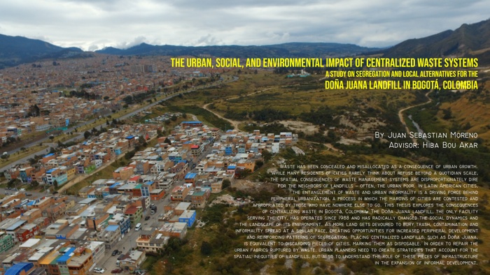
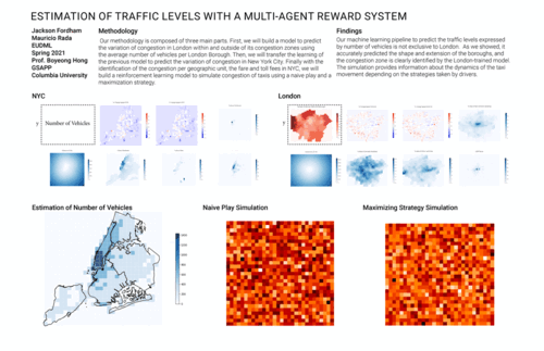
Poster by Juan Sebastian Moreno.
JUAN SEBASTIAN MORENO
The Urban, Social, and Environmental Impact of Centralized Waste Systems
A Study on Segregation and Local Alternatives for the Doña Juana Landfill in Bogotá, Colombia
Advisor: Hiba Bou Akar
Waste has been concealed and misallocated as a consequence of urban growth. While many residents of cities rarely think about refuse beyond a quotidian scale, the spatial consequences of waste management systems are disproportionately dire for the neighbors of landfills – often, the urban poor. In Latin American cities, the entanglement of waste and urban informality is a driving force behind peripheral urbanization, a process in which the margins of cities are contested and appropriated by those who have nowhere else to go. This thesis explores the consequences of centralizing waste in Bogotá, Colombia. The Doña Juana landfill, the only facility serving the city, has operated since 1988 and has radically changed the social dynamics and the landscape of its environment. As more land gets devoured to bury trash, contamination and informality spread at a similar pace, creating opportunities for increased peripheral development and reinforcing patterns of segregation. Placing centralized landfills, such as Doña Juana, is equivalent to discarding pieces of cities, marking them as disposable. In order to repair the urban fabrics ruptured by waste, urban planners need to create strategies that account for the spatial inequities of landfills, but also to understand the role of these pieces of infrastructure in the expansion of informal development.
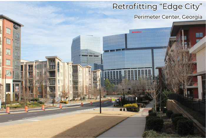
Photo by Nicholas Perry.
NICHOLAS LINCOLN PERRY
Retrofitting “Edge City”: Lessons From Perimeter Center, Georgia
Advisor: Weiping Wu
The growth of metropolitan areas in the American Southeast has placed additional strain on the aging auto-oriented infrastructure of edge cities, the suburban pseudo-downtowns of the late 20th century. Area stakeholders in Perimeter Center outside Atlanta (namely, the Perimeter Community Improvement Districts) cite a housing shortage, crippling traffic congestion, and changing consumer preferences among their reasons to embrace suburban retrofitting strategies under the Atlanta Regional Council’s Livable Centers Initiative – in theory molding the edge city into a form of traditional urban downtown. This thesis determines the effectiveness and legacy of such strategies by employing a two-part methodology – first, by engaging in a discussion of the evolution of notable recent plans through the lens of characteristics of urban downtowns, and secondly, through a field study of completed improvements and developments. Ultimately, the plans succeeded in providing a skeletal civic realm for Perimeter Center’s urban future. Yet, what has emerged atop it is a sort of extreme “hybrid urbanism”, pitting asynchronous architectures, densities, and development types against one another in an arrangement that is nearly as disjointed in practice as its sparse, automobile-scaled past.
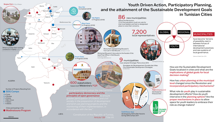
“Youth-driven action, participatory planning, and the attainment of Sustainable Development Goals in Tunisian cities” by Zeineb Sellami
ZEINEB SELLAMI
Youth-driven action, participatory planning, and the attainment of Sustainable Development Goals in Tunisian cities
Advisor: Hiba Bou Akar
Reader: Youssef Cherif
The purpose of this research is to evaluate how youth-driven initiatives and participatory planning within municipalities affect the attainment of the United Nations Sustainable Development Goals for 2030 at the grassroots, municipal, and national levels. The research focuses on post-revolution Tunisia and the changes that have occurred since the Arab Spring transformed the MENA region in 2011. It begins by exploring the SDGs as global frameworks, where attainment is measured at the national level but whose goals are prescribed in more localized contexts, with cities playing a key role. The study then questions the effectiveness of post-revolution decentralization policies on municipal projects and participatory mechanisms. Finally, this thesis explores the advent of multiplying youth-driven grassroots initiatives that, deliberately or unknowingly, align with global sustainability goals.
In addition to archival research on the SDGs and Tunisian municipal structures, the research employs semi-structured interviews allowing for a more in-depth view of the situation at the local level. Interviewees include experts from the UNDP, private sector, international organizations, municipal decision-makers, and youth leaders that spearhead initiatives across their neighborhoods. The aim is to shed light on the rarely discussed role of youth at the intersection of local and global planning frameworks through this Tunisian case-study. Where most research studies focus on a single one of the aforementioned topics, this thesis brings together three levels of inquiry: the global, the national, and the local to shed light onto the complex dynamics that spur and determine planning outcomes in Tunisia’s post-revolutionary context.
XIFAN WANG
The Two Tales of a New Retail Ecosystem: Analyzing How E-commerce Reshapes the Urban Retail Landscape through a Case Study in Shanghai, China
Advisor: Leah Meisterlin
During the last two decades, Information and Communications Technology (ICT) has been recognized as one of the fast-growing urban technology and with ICT, a drastic increase in e-commerce transactions have been observed, threatening the traditional physical retail industry, changing its current network based on distance, and restructuring the existing retail ecosystem. As vast changes due to the new technologies have been observed in China, this study chooses one of the biggest and new technology adapted cities, Shanghai, as a case study and focuses on its local impact induced by e-commerce. This study, positioning in the middle of this change, is thus framed as “the two tales of a new retail ecosystem.”
By analyzing brick-and-mortar (B&M) retail and e-retail, this research aims to have a holistic understanding of the new retail ecosystem in downtown Shanghai. E-commerce trends are examined through local context and relevant reports. Changes in the geographic distribution of retail stores over a year are examined through spatial analysis, Kernel Density Estimation (KDE), on point of interest (POI) datasets of retail stores in Shanghai. Shopping behavior changes due to the emergence of e-commerce as an option are examined by surveys collected at two selected neighborhoods. The survey analysis also implies the potential influence of e-commerce on the conventional retail landscape and links the e-commerce trend and the change in physical retail networks. Convenience goods and comparison goods are categorized to understand the different impacts.
The findings suggest that instead of a one-way effect by e-commerce on the physical retail sector, a mutual relationship exists between the two, leading to a deeply integrated new retail ecosystem, as well as distinct effects on comparison and convenience retail. Being aware of this new system is essential for planners to reconsider the commercial planning for cities. This study proposes a new planning paradigm and other recommendations to address the issue.
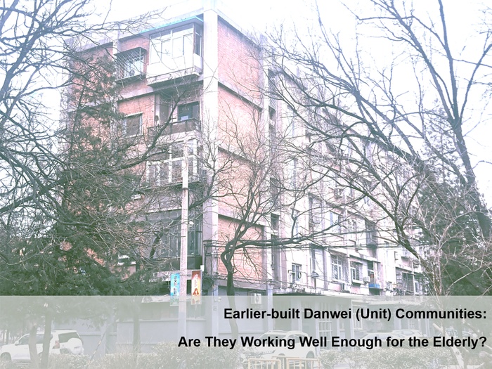
Photo by Jiuyu Wang.
JIUYU WANG
Earlier-built Danwei Communities: Are They Working Well for the Elderly? An Analysis of Bajiaolu Community, Beijing
Advisor: Moira O'Neill
The transformation of communities that were built before 2000 has aroused national attention with the pressing problems caused by China’s aging society. Due to limited building technology and poor management, the outside living environments of earlier-built communities have gradually degraded, compared to those of newly-built communities. Danwei communities, commonly built during the planned economy era, are typical earlier-built communities with degraded outside living environments. There is also a large segment of the elderly population in Danwei communities. In 2017, China piloted 15 cities to help earlier-built communities better adapt to the needs of the aging society. Beijing, in recent years, pioneered its “Jinsong Model” with a comprehensive transformation tool including physical environment renovation, social cohesion enhancement, and financial support. Other earlier-built communities in China have gradually become the objects of community renovation projects. Among them, a worse living condition is found in the communities that had been originally built as Danwei communities. This thesis study analyzes the existing problems of the outside environment of Bajiaolu community, one former Danwei community constructed by Shougang Enterprise. The conclusions of this study are based on observations of the physical environment of this community and the daily outdoor behavioral characteristics of senior residents. My results show the needs of the elderly for better living environments and behavioral requirements on the living environment to be more convenient. By comparing the needs of the residents and the existing physical environments of their community, this study finds that Bajiaolu community is far from offering good service for the elderly. Based on the findings of this study, I recommend three strategies to improve the outdoor shared spaces to improve the quality of life of residents in earlier-built Danwei communities in China: (1) differentiate community outdoor spaces, (2) enrich the functions of these outdoor space, and (3) ensure that comfort is included as an important element in the design of the spaces now and in the future.
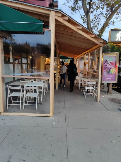
Photo of a restaurant in Greenwich Village by Hanzhang Yang.
HANZHANG YANG
Outdoor Dining during COVID? Analyzing the Impact of New York City’s Open Restaurants Program
Advisor: Hiba Bou Akar
The purpose of this research is to understand better the conflicts developed by New York City’s Open Restaurants program, which intends to help the city’s hospitality industry rebound during the COVID-19 pandemic. This research proposed that the Open Restaurants program’s predecessor will be the Sidewalk Cafes program. Still, its state of exception nature eliminates the community governing process, encourages the future privatization of public space, and creates conflicts on the access to sidewalks. Through historical and theoretical research on urban planning, government policy, and urban studies, the research argued that the Open Restaurants program was a faux revival of the falling public life when it failed to create or resume connection between users of the street. The author also gave recommendations to the Open Restaurants program to protect equitable access to sidewalks and strengthen community autonomy.
Capstone project presentation by Angel Yin.
ANGEL YIN
Envision Spring Creek: Resilience Assessment and Recommendations for Addressing Layered Risks
Advisor: Moira O'Neill
New York City and many other cities around the world are experiencing increased risks to climate change and its related climate problems. Hurricane Sandy exposed the vulnerability of NYC’s communities with devastating consequences, many of which are will come back in the future. Meanwhile, affordable housing, as an important component for both the community and city, needs to respond to various urban needs and the increasing risks of climate change. As the city looks to be a global leader in fighting against climate change while striving to provide affordable housings to more New Yorkers, it is imperative that city agencies work with communities to plan for a resilient and affordable future.
Spring Creek is a waterfront neighborhood in the East New York portion of Brooklyn in New York City, within Brooklyn Community District 5. It is named after Spring Creek, a creek that runs through the area and goes into Jamaica Bay. Like many other communities in New York City, Spring Creek experienced various kinds of climate and environmental hazards in the last few decades. For example, Industrial activities and lack of tree canopies worsen the Urban Heat Island (UHI) effect and outdoor air pollution. However, similar to all out-lying communities in NYC, Spring Creek is physically isolated from most central city resources. This physical isolation exacerbates resident’s ability to cope with climate hazards if happening, as well as highlights the challenge of limited access to resilient and affordable services and amenities such as housing and healthcare.
Partnering with HPD, this capstone project conducted a comprehensive analysis on the level of resilience of an identified study area in the neighborhood of Spring Creek, Brooklyn. By conducting an initial study and an indicator-based resiliency assessment, the project identifies existing risks and hazards prone to the neighborhood and provides a concept plan with recommended mitigation measures that would help increase the level of resiliency. The purpose of this project is to help HPD envision a livable, sustainable, and affordable future for Spring Creek.
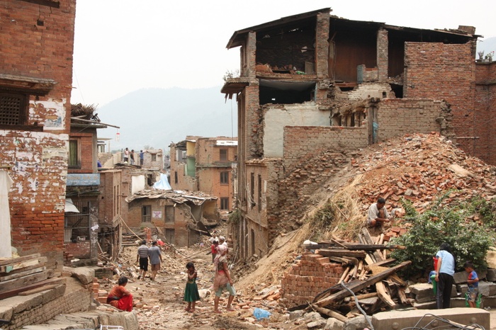
Photo by Shinichi Yoshihara.
SHINICHI YOSHIHARA
Rebuilding a Historic City: Post-Disaster Housing Reconstruction in Bhaktapur, Nepal
Advisor: Hiba Bou Akar
A crisis can turn into an opportunity to change. The larger the crisis is, the motivation for a change becomes more significant. A devastating earthquake in 2015 motivated Nepal to build more resilient housings nationwide that would not collapse by future earthquakes. With the Build Back Better concept in mind, the national housing reconstruction program helped disaster-affected people rebuild their earthquake-resistant homes. However, existing studies suggest that historic settlements in Kathmandu Valley are losing their historic values due to the earthquake damage itself and the recovery interventions.
Through a single case study with archival research, my thesis investigates how the post-disaster planning interventions, specifically the national housing reconstruction program, have impacted Bhaktapur’s old town. The result shows that the housing reconstruction program brought about a long-lasting transformation of the old town. The overall assumption of the program was based on rural areas, which does not necessarily address the complexities of urban settlements. One of the reasons behind this is the spatial preference of the international institutions and other development partners that selected rural areas as their targeted sites. This created an unintended new set of vulnerable populations in urban areas and de-densification of the old town. Furthermore, the narrowly defined Build Back Better recovery accelerated the change of the old town instead of conserving it. The brick masonry with earthen mortar, historically used in Newari settlements, could not be practically applied to three- or four-story urban housing reconstruction because of the structural requirements of the National Building Code.
HAORAN ZHANG
The Child-Friendly City, Planning Analysis in Beijing: The Case Study of Beijing Shuangjing Community
Advisor: Malo Hutson
Child-friendly City is quite a new planning concept in China that did not arise until the 2010s. In recent years, many Chinese cities released their Child-friendly City Strategic Planning which highlighted the children’s right, growth, and opportunities and started to apply the concept into practice in planning projects. This study illustrates knowledge of child-friendly city planning by discussing the current child-friendly planning policies in Beijing and using Shuangjing Community as a case study to analyze children’s participation in the planning process. Interviews are made with different stakeholders, which help identify the community engagement plan involved, examine children’s roles and positions, and investigate their interactions. Finally, a couple of recommendations are proposed for a better child-friendly Beijing.